You are here: Home > Network List > PY - PFO Array Stations List
> Station BPH06 Pinon Flat Observatory, CA, USA > Earthquake Result Viewer
BPH06 Pinon Flat Observatory, CA, USA - Earthquake Result Viewer
| Earthquake location: |
Solomon Islands |
| Earthquake latitude/longitude: |
-11.3/162.2 |
| Earthquake time(UTC): |
2014/04/12 (102) 20:14:39 GMT |
| Earthquake Depth: |
29 km |
| Earthquake Magnitude: |
7.6 MWW, 8.3 MI |
| Earthquake Catalog/Contributor: |
NEIC PDE/NEIC COMCAT |
|
| Network: |
PY PFO Array |
| Station: |
BPH06 Pinon Flat Observatory, CA, USA |
| Lat/Lon: |
33.61 N/116.45 W |
| Elevation: |
1294 m |
|
| Distance: |
89.1 deg |
| Az: |
55.6 deg |
| Baz: |
255.87 deg |
| Ray Param: |
0.042070314 |
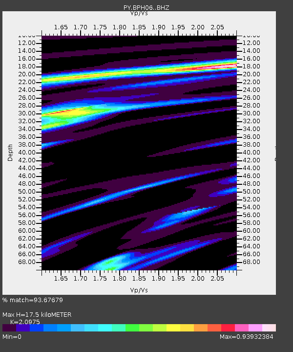
| Estimated Moho Depth: |
17.5 km |
| Estimated Crust Vp/Vs: |
2.10 |
| Assumed Crust Vp: |
6.264 km/s |
| Estimated Crust Vs: |
2.986 km/s |
| Estimated Crust Poisson's Ratio: |
0.35 |
|
| Radial Match: |
93.67679 % |
| Radial Bump: |
286 |
| Transverse Match: |
85.77194 % |
| Transverse Bump: |
400 |
| SOD ConfigId: |
3390531 |
| Insert Time: |
2019-04-11 08:07:21.431 +0000 |
| GWidth: |
2.5 |
| Max Bumps: |
400 |
| Tol: |
0.001 |
|

Signal To Noise
| Channel | StoN | STA | LTA |
| PY:BPH06: :BHZ:20140412T20:27:01.625005Z | 5.302213 | 1.0925129E-6 | 2.0604847E-7 |
| PY:BPH06: :BHN:20140412T20:27:01.625005Z | 0.7966553 | 1.18652565E-7 | 1.4893841E-7 |
| PY:BPH06: :BHE:20140412T20:27:01.625005Z | 3.2826812 | 3.9185082E-7 | 1.1936913E-7 |
| Arrivals |
| Ps | 3.1 SECOND |
| PpPs | 8.5 SECOND |
| PsPs/PpSs | 12 SECOND |


