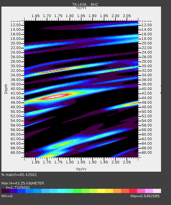
L43A Garden Prairie, IL, USA - Earthquake Result Viewer
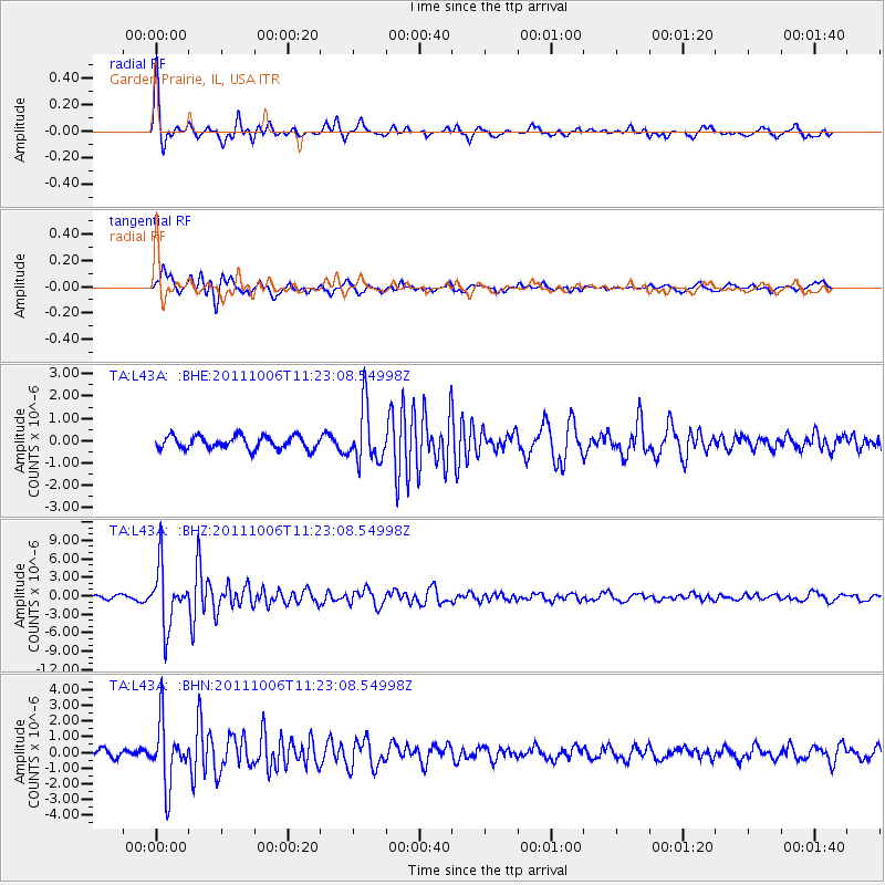
Earthquake location: Salta Province, Argentina
Earthquake latitude/longitude: -24.2/-64.2
Earthquake time(UTC): 2011/10/06 (279) 11:12:30 GMT
Earthquake Depth: 15 km
Earthquake Magnitude: 6.5 MB, 5.7 MS, 6.1 MW, 5.9 MW
Earthquake Catalog/Contributor: WHDF/NEIC
Network: TA USArray Transportable Network (new EarthScope stations)
Station: L43A Garden Prairie, IL, USA
Lat/Lon: 42.18 N/88.74 W
Elevation: 266 m
Distance: 69.8 deg
Az: 340.811 deg
Baz: 156.179 deg
Ray Param: 0.05538723
Estimated Moho Depth: 43.25 km
Estimated Crust Vp/Vs: 1.73
Assumed Crust Vp: 6.571 km/s
Estimated Crust Vs: 3.793 km/s
Estimated Crust Poisson's Ratio: 0.25
Radial Match: 90.42582 %
Radial Bump: 342
Transverse Match: 84.07438 %
Transverse Bump: 400
SOD ConfigId: 424168
Insert Time: 2012-02-04 06:18:51.203 +0000
GWidth: 2.5
Max Bumps: 400
Tol: 0.001

Signal To Noise

ChannelStoNSTALTA
TA:L43A: :BHZ:20111006T11:23:08.54998Z18.049274.726231E-62.6185165E-7
TA:L43A: :BHN:20111006T11:23:08.54998Z7.5678321.950474E-62.5773218E-7
TA:L43A: :BHE:20111006T11:23:08.54998Z4.3124941.2287456E-62.8492695E-7
Arrivals
Ps5.0 SECOND
PpPs17 SECOND
PsPs/PpSs22 SECOND