You are here: Home > Network List > TO - Tectonic Observatory Stations List
> Station CC37 CCSE CC37 > Earthquake Result Viewer
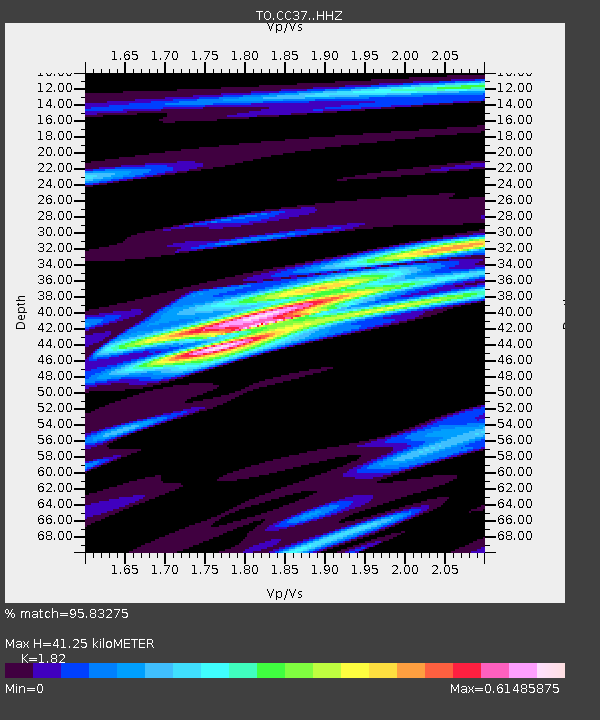
CC37 CCSE CC37 - Earthquake Result Viewer
| Earthquake location: |
Solomon Islands |
| Earthquake latitude/longitude: |
-11.3/162.2 |
| Earthquake time(UTC): |
2014/04/12 (102) 20:14:39 GMT |
| Earthquake Depth: |
29 km |
| Earthquake Magnitude: |
7.6 MWW, 8.3 MI |
| Earthquake Catalog/Contributor: |
NEIC PDE/NEIC COMCAT |
|
| Network: |
TO Tectonic Observatory |
| Station: |
CC37 CCSE CC37 |
| Lat/Lon: |
36.39 N/118.90 W |
| Elevation: |
654 m |
|
| Distance: |
87.9 deg |
| Az: |
52.405 deg |
| Baz: |
254.388 deg |
| Ray Param: |
0.042982116 |
| Estimated Moho Depth: |
41.25 km |
| Estimated Crust Vp/Vs: |
1.82 |
| Assumed Crust Vp: |
6.291 km/s |
| Estimated Crust Vs: |
3.457 km/s |
| Estimated Crust Poisson's Ratio: |
0.28 |
|
| Radial Match: |
95.83275 % |
| Radial Bump: |
291 |
| Transverse Match: |
95.83275 % |
| Transverse Bump: |
291 |
| SOD ConfigId: |
3390531 |
| Insert Time: |
2019-04-11 08:08:08.135 +0000 |
| GWidth: |
2.5 |
| Max Bumps: |
400 |
| Tol: |
0.001 |
|

Signal To Noise
| Channel | StoN | STA | LTA |
| TO:CC37: :HHZ:20140412T20:26:55.779973Z | 14.067122 | 1.6368808E-6 | 1.16362166E-7 |
| $trig.getChannelId() | $trig.getValue() | $trig.getSTA() | $trig.getLTA() |
| TO:CC37: :HHE:20140412T20:26:55.779973Z | 5.3472567 | 5.1044174E-7 | 9.545862E-8 |
| Arrivals |
| Ps | 5.5 SECOND |
| PpPs | 18 SECOND |
| PsPs/PpSs | 24 SECOND |


