You are here: Home > Network List > UW - Pacific Northwest Regional Seismic Network Stations List
> Station LEBA Lebam, WA, USA > Earthquake Result Viewer
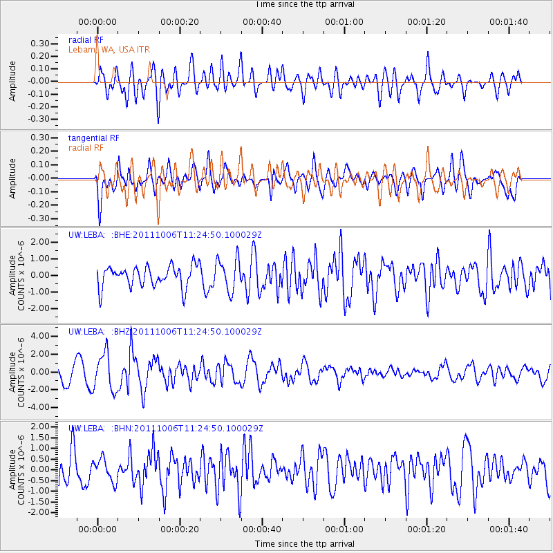
LEBA Lebam, WA, USA - Earthquake Result Viewer
*The percent match for this event was below the threshold and hence no stack was calculated.
| Earthquake location: |
Salta Province, Argentina |
| Earthquake latitude/longitude: |
-24.2/-64.2 |
| Earthquake time(UTC): |
2011/10/06 (279) 11:12:30 GMT |
| Earthquake Depth: |
15 km |
| Earthquake Magnitude: |
6.5 MB, 5.7 MS, 6.1 MW, 5.9 MW |
| Earthquake Catalog/Contributor: |
WHDF/NEIC |
|
| Network: |
UW Pacific Northwest Regional Seismic Network |
| Station: |
LEBA Lebam, WA, USA |
| Lat/Lon: |
46.55 N/123.56 W |
| Elevation: |
73 m |
|
| Distance: |
88.5 deg |
| Az: |
323.562 deg |
| Baz: |
128.192 deg |
| Ray Param: |
$rayparam |
*The percent match for this event was below the threshold and hence was not used in the summary stack. |
|
| Radial Match: |
65.169365 % |
| Radial Bump: |
400 |
| Transverse Match: |
59.937122 % |
| Transverse Bump: |
400 |
| SOD ConfigId: |
424168 |
| Insert Time: |
2012-02-04 06:21:32.870 +0000 |
| GWidth: |
2.5 |
| Max Bumps: |
400 |
| Tol: |
0.001 |
|
Signal To Noise
| Channel | StoN | STA | LTA |
| UW:LEBA: :BHZ:20111006T11:24:50.100029Z | 1.7495532 | 2.1098729E-6 | 1.2059495E-6 |
| UW:LEBA: :BHN:20111006T11:24:50.100029Z | 0.6535908 | 5.33751E-7 | 8.1664393E-7 |
| UW:LEBA: :BHE:20111006T11:24:50.100029Z | 1.5881654 | 1.0000317E-6 | 6.296773E-7 |
| Arrivals |
| Ps | |
| PpPs | |
| PsPs/PpSs | |


