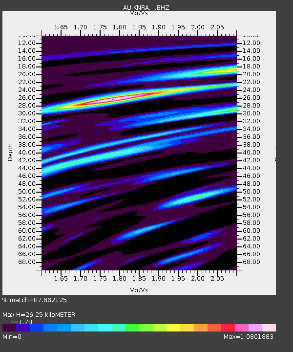
KNRA Kunnunarra, Western Australia - Earthquake Result Viewer

Earthquake location: South Of Kermadec Islands
Earthquake latitude/longitude: -32.5/-179.0
Earthquake time(UTC): 2011/10/07 (280) 08:58:28 GMT
Earthquake Depth: 36 km
Earthquake Magnitude: 5.9 MB, 5.8 MS, 6.1 MW, 6.1 MW
Earthquake Catalog/Contributor: WHDF/NEIC
Network: AU Australian Seismological Centre
Station: KNRA Kunnunarra, Western Australia
Lat/Lon: 15.68 S/128.76 E
Elevation: 101 m
Distance: 50.0 deg
Az: 276.666 deg
Baz: 119.404 deg
Ray Param: 0.06825687
Estimated Moho Depth: 26.25 km
Estimated Crust Vp/Vs: 1.78
Assumed Crust Vp: 6.397 km/s
Estimated Crust Vs: 3.594 km/s
Estimated Crust Poisson's Ratio: 0.27
Radial Match: 87.662125 %
Radial Bump: 400
Transverse Match: 69.78339 %
Transverse Bump: 400
SOD ConfigId: 424168
Insert Time: 2012-02-04 06:37:18.430 +0000
GWidth: 2.5
Max Bumps: 400
Tol: 0.001

Signal To Noise

ChannelStoNSTALTA
AU:KNRA: :BHZ:20111007T09:06:49.269985Z7.95162962.2702577E-62.855085E-7
AU:KNRA: :BHN:20111007T09:06:49.269985Z2.26665125.025541E-72.2171653E-7
AU:KNRA: :BHE:20111007T09:06:49.269985Z8.6041659.2907214E-71.0797934E-7
Arrivals
Ps3.4 SECOND
PpPs11 SECOND
PsPs/PpSs14 SECOND