You are here: Home > Network List > AZ - ANZA Regional Network Stations List
> Station SMER AZ.SMER > Earthquake Result Viewer
SMER AZ.SMER - Earthquake Result Viewer
*The percent match for this event was below the threshold and hence no stack was calculated.
| Earthquake location: |
South Of Kermadec Islands |
| Earthquake latitude/longitude: |
-32.5/-179.0 |
| Earthquake time(UTC): |
2011/10/07 (280) 08:58:28 GMT |
| Earthquake Depth: |
36 km |
| Earthquake Magnitude: |
5.9 MB, 5.8 MS, 6.1 MW, 6.1 MW |
| Earthquake Catalog/Contributor: |
WHDF/NEIC |
|
| Network: |
AZ ANZA Regional Network |
| Station: |
SMER AZ.SMER |
| Lat/Lon: |
33.46 N/117.17 W |
| Elevation: |
355 m |
|
| Distance: |
87.7 deg |
| Az: |
47.544 deg |
| Baz: |
228.215 deg |
| Ray Param: |
$rayparam |
*The percent match for this event was below the threshold and hence was not used in the summary stack. |
|
| Radial Match: |
36.7524 % |
| Radial Bump: |
385 |
| Transverse Match: |
52.432545 % |
| Transverse Bump: |
400 |
| SOD ConfigId: |
424168 |
| Insert Time: |
2012-02-04 06:39:38.188 +0000 |
| GWidth: |
2.5 |
| Max Bumps: |
400 |
| Tol: |
0.001 |
|
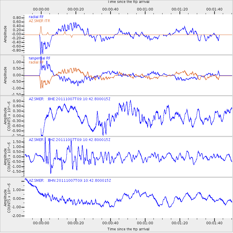
Signal To Noise
| Channel | StoN | STA | LTA |
| AZ:SMER: :BHZ:20111007T09:10:42.800015Z | 2.1980157 | 6.5519083E-7 | 2.9808288E-7 |
| AZ:SMER: :BHN:20111007T09:10:42.800015Z | 0.5025243 | 1.3720808E-6 | 2.730377E-6 |
| AZ:SMER: :BHE:20111007T09:10:42.800015Z | 1.6006049 | 7.3651654E-7 | 4.6014887E-7 |
| Arrivals |
| Ps | |
| PpPs | |
| PsPs/PpSs | |


