You are here: Home > Network List > IC - New China Digital Seismograph Network Stations List
> Station ENH Enshi, Hubei Province, China > Earthquake Result Viewer
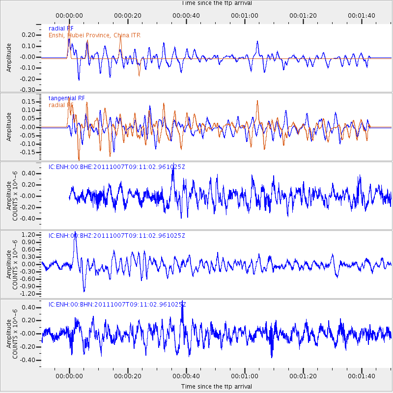
ENH Enshi, Hubei Province, China - Earthquake Result Viewer
*The percent match for this event was below the threshold and hence no stack was calculated.
| Earthquake location: |
South Of Kermadec Islands |
| Earthquake latitude/longitude: |
-32.5/-179.0 |
| Earthquake time(UTC): |
2011/10/07 (280) 08:58:28 GMT |
| Earthquake Depth: |
36 km |
| Earthquake Magnitude: |
5.9 MB, 5.8 MS, 6.1 MW, 6.1 MW |
| Earthquake Catalog/Contributor: |
WHDF/NEIC |
|
| Network: |
IC New China Digital Seismograph Network |
| Station: |
ENH Enshi, Hubei Province, China |
| Lat/Lon: |
30.28 N/109.49 E |
| Elevation: |
500 m |
|
| Distance: |
92.1 deg |
| Az: |
304.84 deg |
| Baz: |
126.717 deg |
| Ray Param: |
$rayparam |
*The percent match for this event was below the threshold and hence was not used in the summary stack. |
|
| Radial Match: |
63.97139 % |
| Radial Bump: |
400 |
| Transverse Match: |
60.7706 % |
| Transverse Bump: |
400 |
| SOD ConfigId: |
424168 |
| Insert Time: |
2012-02-04 06:47:41.447 +0000 |
| GWidth: |
2.5 |
| Max Bumps: |
400 |
| Tol: |
0.001 |
|
Signal To Noise
| Channel | StoN | STA | LTA |
| IC:ENH:00:BHZ:20111007T09:11:02.961025Z | 6.4167433 | 5.375982E-7 | 8.378054E-8 |
| IC:ENH:00:BHN:20111007T09:11:02.961025Z | 1.6638486 | 1.3030139E-7 | 7.831325E-8 |
| IC:ENH:00:BHE:20111007T09:11:02.961025Z | 1.2894553 | 1.2961476E-7 | 1.00518996E-7 |
| Arrivals |
| Ps | |
| PpPs | |
| PsPs/PpSs | |


