You are here: Home > Network List > AV - Alaska Volcano Observatory Stations List
> Station SPCR Ckakachatna River, Mount Spurr, Alaska > Earthquake Result Viewer
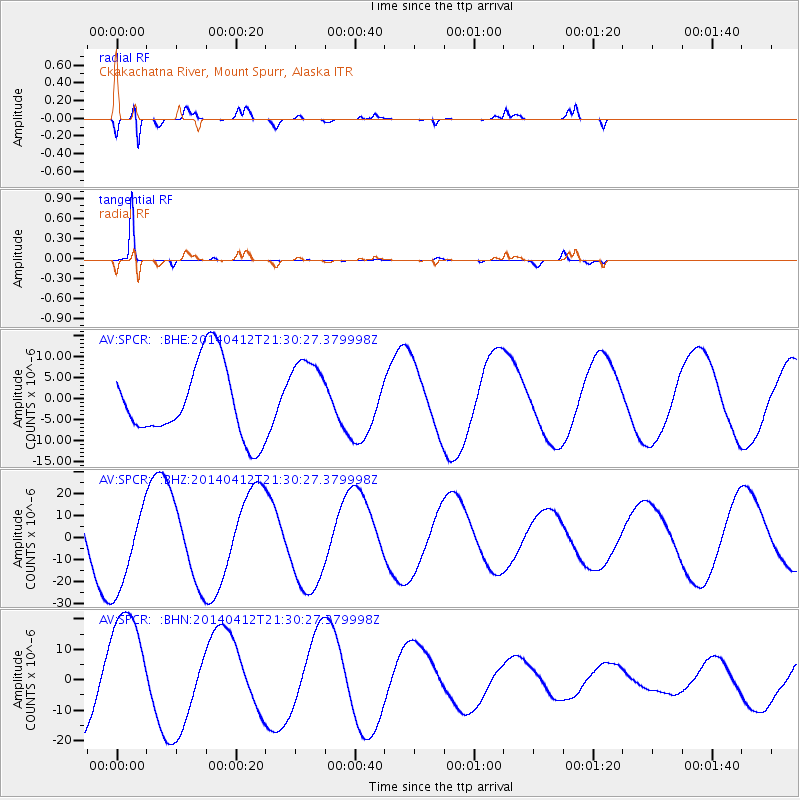
SPCR Ckakachatna River, Mount Spurr, Alaska - Earthquake Result Viewer
*The percent match for this event was below the threshold and hence no stack was calculated.
| Earthquake location: |
E. Russia-N.E. China Border Reg. |
| Earthquake latitude/longitude: |
44.9/133.7 |
| Earthquake time(UTC): |
2014/04/12 (102) 21:22:44 GMT |
| Earthquake Depth: |
10 km |
| Earthquake Magnitude: |
4.3 mb |
| Earthquake Catalog/Contributor: |
ISC/ISC |
|
| Network: |
AV Alaska Volcano Observatory |
| Station: |
SPCR Ckakachatna River, Mount Spurr, Alaska |
| Lat/Lon: |
61.20 N/152.21 W |
| Elevation: |
984 m |
|
| Distance: |
44.8 deg |
| Az: |
41.387 deg |
| Baz: |
283.987 deg |
| Ray Param: |
$rayparam |
*The percent match for this event was below the threshold and hence was not used in the summary stack. |
|
| Radial Match: |
91.84557 % |
| Radial Bump: |
400 |
| Transverse Match: |
98.1841 % |
| Transverse Bump: |
104 |
| SOD ConfigId: |
3390531 |
| Insert Time: |
2019-04-11 08:14:33.338 +0000 |
| GWidth: |
2.5 |
| Max Bumps: |
400 |
| Tol: |
0.001 |
|
Signal To Noise
| Channel | StoN | STA | LTA |
| AV:SPCR: :BHZ:20140412T21:30:27.379998Z | 1.2566061 | 2.0501588E-5 | 1.6315047E-5 |
| AV:SPCR: :BHN:20140412T21:30:27.379998Z | 1.8307633 | 2.0156143E-5 | 1.1009694E-5 |
| AV:SPCR: :BHE:20140412T21:30:27.379998Z | 1.0337402 | 9.059928E-6 | 8.764221E-6 |
| Arrivals |
| Ps | |
| PpPs | |
| PsPs/PpSs | |


