You are here: Home > Network List > AR - Northern Arizona Network Stations List
> Station U15A North Rim, AZ, USA > Earthquake Result Viewer
U15A North Rim, AZ, USA - Earthquake Result Viewer
| Earthquake location: |
Tonga Islands |
| Earthquake latitude/longitude: |
-20.6/-173.2 |
| Earthquake time(UTC): |
2011/10/08 (281) 08:53:11 GMT |
| Earthquake Depth: |
6.0 km |
| Earthquake Magnitude: |
6.1 MB, 5.6 MS, 5.9 MW, 5.9 MW |
| Earthquake Catalog/Contributor: |
WHDF/NEIC |
|
| Network: |
AR Northern Arizona Network |
| Station: |
U15A North Rim, AZ, USA |
| Lat/Lon: |
36.43 N/112.29 W |
| Elevation: |
2489 m |
|
| Distance: |
80.8 deg |
| Az: |
45.573 deg |
| Baz: |
236.051 deg |
| Ray Param: |
0.048053928 |
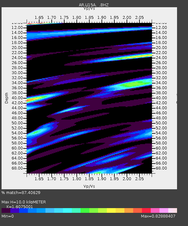
| Estimated Moho Depth: |
10.0 km |
| Estimated Crust Vp/Vs: |
1.61 |
| Assumed Crust Vp: |
6.194 km/s |
| Estimated Crust Vs: |
3.853 km/s |
| Estimated Crust Poisson's Ratio: |
0.18 |
|
| Radial Match: |
87.40629 % |
| Radial Bump: |
400 |
| Transverse Match: |
72.370384 % |
| Transverse Bump: |
400 |
| SOD ConfigId: |
424168 |
| Insert Time: |
2012-02-08 00:57:58.804 +0000 |
| GWidth: |
2.5 |
| Max Bumps: |
400 |
| Tol: |
0.001 |
|

Signal To Noise
| Channel | StoN | STA | LTA |
| AR:U15A: :BHZ:20111008T09:04:54.800027Z | 7.510612 | 1.3829272E-6 | 1.8412976E-7 |
| AR:U15A: :BHN:20111008T09:04:54.800027Z | 1.1588295 | 2.1609026E-7 | 1.8647287E-7 |
| AR:U15A: :BHE:20111008T09:04:54.800027Z | 3.2692099 | 5.2196543E-7 | 1.5966104E-7 |
| Arrivals |
| Ps | 1.0 SECOND |
| PpPs | 4.1 SECOND |
| PsPs/PpSs | 5.1 SECOND |


