You are here: Home > Network List > TA - USArray Transportable Network (new EarthScope stations) Stations List
> Station 121A Cookes Peak, Deming, NM, USA > Earthquake Result Viewer
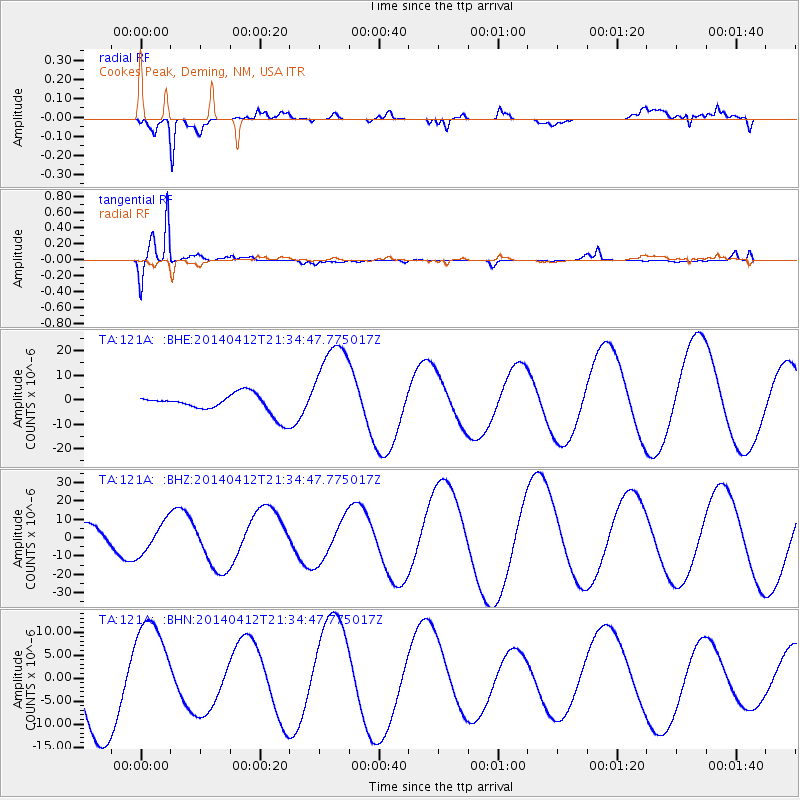
121A Cookes Peak, Deming, NM, USA - Earthquake Result Viewer
*The percent match for this event was below the threshold and hence no stack was calculated.
| Earthquake location: |
E. Russia-N.E. China Border Reg. |
| Earthquake latitude/longitude: |
44.9/133.7 |
| Earthquake time(UTC): |
2014/04/12 (102) 21:22:44 GMT |
| Earthquake Depth: |
10 km |
| Earthquake Magnitude: |
4.3 mb |
| Earthquake Catalog/Contributor: |
ISC/ISC |
|
| Network: |
TA USArray Transportable Network (new EarthScope stations) |
| Station: |
121A Cookes Peak, Deming, NM, USA |
| Lat/Lon: |
32.53 N/107.79 W |
| Elevation: |
1652 m |
|
| Distance: |
84.8 deg |
| Az: |
48.179 deg |
| Baz: |
321.171 deg |
| Ray Param: |
$rayparam |
*The percent match for this event was below the threshold and hence was not used in the summary stack. |
|
| Radial Match: |
72.30099 % |
| Radial Bump: |
400 |
| Transverse Match: |
93.83674 % |
| Transverse Bump: |
326 |
| SOD ConfigId: |
3390531 |
| Insert Time: |
2019-04-11 08:18:57.870 +0000 |
| GWidth: |
2.5 |
| Max Bumps: |
400 |
| Tol: |
0.001 |
|
Signal To Noise
| Channel | StoN | STA | LTA |
| TA:121A: :BHZ:20140412T21:34:47.775017Z | 1.4032362 | 8.603868E-6 | 6.131447E-6 |
| TA:121A: :BHN:20140412T21:34:47.775017Z | 1.7071604 | 1.1241172E-5 | 6.5847194E-6 |
| TA:121A: :BHE:20140412T21:34:47.775017Z | 4.8452187 | 1.9330997E-5 | 3.989706E-6 |
| Arrivals |
| Ps | |
| PpPs | |
| PsPs/PpSs | |


