You are here: Home > Network List > CI - Caltech Regional Seismic Network Stations List
> Station SLA SLA, Trona, CA, USA > Earthquake Result Viewer
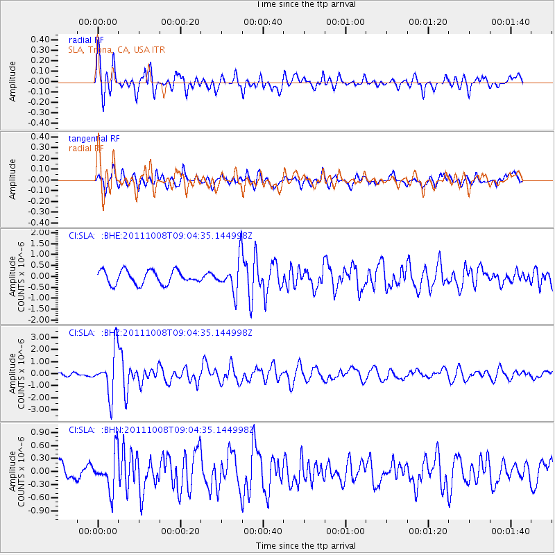
SLA SLA, Trona, CA, USA - Earthquake Result Viewer
*The percent match for this event was below the threshold and hence no stack was calculated.
| Earthquake location: |
Tonga Islands |
| Earthquake latitude/longitude: |
-20.6/-173.2 |
| Earthquake time(UTC): |
2011/10/08 (281) 08:53:11 GMT |
| Earthquake Depth: |
6.0 km |
| Earthquake Magnitude: |
6.1 MB, 5.6 MS, 5.9 MW, 5.9 MW |
| Earthquake Catalog/Contributor: |
WHDF/NEIC |
|
| Network: |
CI Caltech Regional Seismic Network |
| Station: |
SLA SLA, Trona, CA, USA |
| Lat/Lon: |
35.89 N/117.28 W |
| Elevation: |
1174 m |
|
| Distance: |
77.2 deg |
| Az: |
43.621 deg |
| Baz: |
232.744 deg |
| Ray Param: |
$rayparam |
*The percent match for this event was below the threshold and hence was not used in the summary stack. |
|
| Radial Match: |
77.231575 % |
| Radial Bump: |
400 |
| Transverse Match: |
70.075905 % |
| Transverse Bump: |
400 |
| SOD ConfigId: |
424168 |
| Insert Time: |
2012-02-08 01:06:00.160 +0000 |
| GWidth: |
2.5 |
| Max Bumps: |
400 |
| Tol: |
0.001 |
|
Signal To Noise
| Channel | StoN | STA | LTA |
| CI:SLA: :BHZ:20111008T09:04:35.144998Z | 11.841374 | 1.8989565E-6 | 1.6036621E-7 |
| CI:SLA: :BHN:20111008T09:04:35.144998Z | 3.1138203 | 4.3480298E-7 | 1.396365E-7 |
| CI:SLA: :BHE:20111008T09:04:35.144998Z | 2.6609235 | 8.2038724E-7 | 3.083092E-7 |
| Arrivals |
| Ps | |
| PpPs | |
| PsPs/PpSs | |


