You are here: Home > Network List > IC - New China Digital Seismograph Network Stations List
> Station BJT Baijiatuan, Beijing, China > Earthquake Result Viewer
BJT Baijiatuan, Beijing, China - Earthquake Result Viewer
| Earthquake location: |
Tonga Islands |
| Earthquake latitude/longitude: |
-20.6/-173.2 |
| Earthquake time(UTC): |
2011/10/08 (281) 08:53:11 GMT |
| Earthquake Depth: |
6.0 km |
| Earthquake Magnitude: |
6.1 MB, 5.6 MS, 5.9 MW, 5.9 MW |
| Earthquake Catalog/Contributor: |
WHDF/NEIC |
|
| Network: |
IC New China Digital Seismograph Network |
| Station: |
BJT Baijiatuan, Beijing, China |
| Lat/Lon: |
40.02 N/116.17 E |
| Elevation: |
197 m |
|
| Distance: |
89.2 deg |
| Az: |
313.574 deg |
| Baz: |
117.898 deg |
| Ray Param: |
0.042065218 |
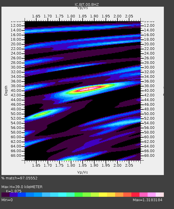
| Estimated Moho Depth: |
39.0 km |
| Estimated Crust Vp/Vs: |
1.88 |
| Assumed Crust Vp: |
6.464 km/s |
| Estimated Crust Vs: |
3.447 km/s |
| Estimated Crust Poisson's Ratio: |
0.30 |
|
| Radial Match: |
97.05552 % |
| Radial Bump: |
305 |
| Transverse Match: |
91.612755 % |
| Transverse Bump: |
369 |
| SOD ConfigId: |
424168 |
| Insert Time: |
2012-02-08 01:10:14.479 +0000 |
| GWidth: |
2.5 |
| Max Bumps: |
400 |
| Tol: |
0.001 |
|
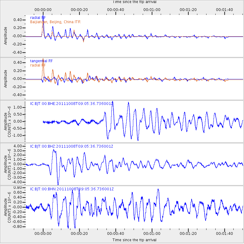
Signal To Noise
| Channel | StoN | STA | LTA |
| IC:BJT:00:BHZ:20111008T09:05:36.736001Z | 9.823934 | 8.261658E-7 | 8.4097245E-8 |
| IC:BJT:00:BHN:20111008T09:05:36.736001Z | 2.9968982 | 1.7134496E-7 | 5.7174102E-8 |
| IC:BJT:00:BHE:20111008T09:05:36.736001Z | 3.4186862 | 2.6422916E-7 | 7.7289684E-8 |
| Arrivals |
| Ps | 5.4 SECOND |
| PpPs | 17 SECOND |
| PsPs/PpSs | 22 SECOND |


