You are here: Home > Network List > IU - Global Seismograph Network (GSN - IRIS/USGS) Stations List
> Station SBA Scott Base, Antarctica > Earthquake Result Viewer
SBA Scott Base, Antarctica - Earthquake Result Viewer
| Earthquake location: |
Tonga Islands |
| Earthquake latitude/longitude: |
-20.6/-173.2 |
| Earthquake time(UTC): |
2011/10/08 (281) 08:53:11 GMT |
| Earthquake Depth: |
6.0 km |
| Earthquake Magnitude: |
6.1 MB, 5.6 MS, 5.9 MW, 5.9 MW |
| Earthquake Catalog/Contributor: |
WHDF/NEIC |
|
| Network: |
IU Global Seismograph Network (GSN - IRIS/USGS) |
| Station: |
SBA Scott Base, Antarctica |
| Lat/Lon: |
77.85 S/166.76 E |
| Elevation: |
50 m |
|
| Distance: |
58.1 deg |
| Az: |
184.9 deg |
| Baz: |
22.195 deg |
| Ray Param: |
0.06306937 |
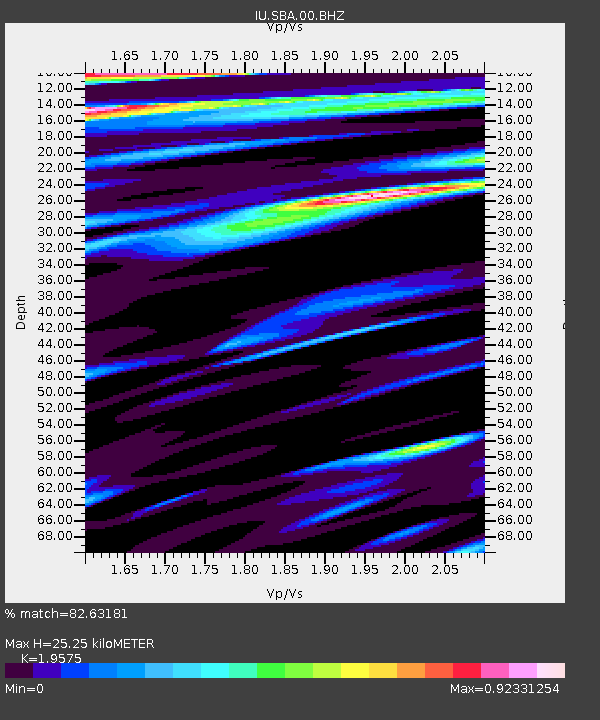
| Estimated Moho Depth: |
25.25 km |
| Estimated Crust Vp/Vs: |
1.96 |
| Assumed Crust Vp: |
6.183 km/s |
| Estimated Crust Vs: |
3.158 km/s |
| Estimated Crust Poisson's Ratio: |
0.32 |
|
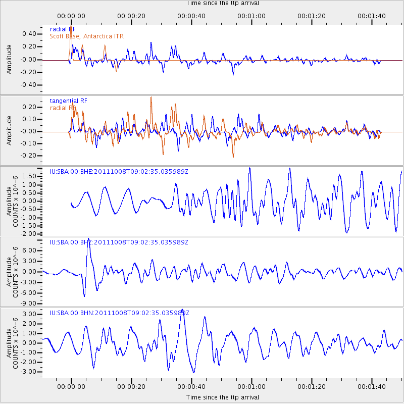
| Radial Match: |
82.63181 % |
| Radial Bump: |
400 |
| Transverse Match: |
76.49923 % |
| Transverse Bump: |
318 |
| SOD ConfigId: |
424168 |
| Insert Time: |
2012-02-08 01:11:05.327 +0000 |
| GWidth: |
2.5 |
| Max Bumps: |
400 |
| Tol: |
0.001 |
|
Signal To Noise
| Channel | StoN | STA | LTA |
| IU:SBA:00:BHZ:20111008T09:02:35.035989Z | 6.4881873 | 2.2676438E-6 | 3.4950347E-7 |
| IU:SBA:00:BHN:20111008T09:02:35.035989Z | 2.7413116 | 9.229102E-7 | 3.366674E-7 |
| IU:SBA:00:BHE:20111008T09:02:35.035989Z | 0.8350671 | 3.9888278E-7 | 4.7766554E-7 |
| Arrivals |
| Ps | 4.1 SECOND |
| PpPs | 12 SECOND |
| PsPs/PpSs | 16 SECOND |


