You are here: Home > Network List > IW - Intermountain West Stations List
> Station MOOW Moose Ponds, Wyoming, USA > Earthquake Result Viewer
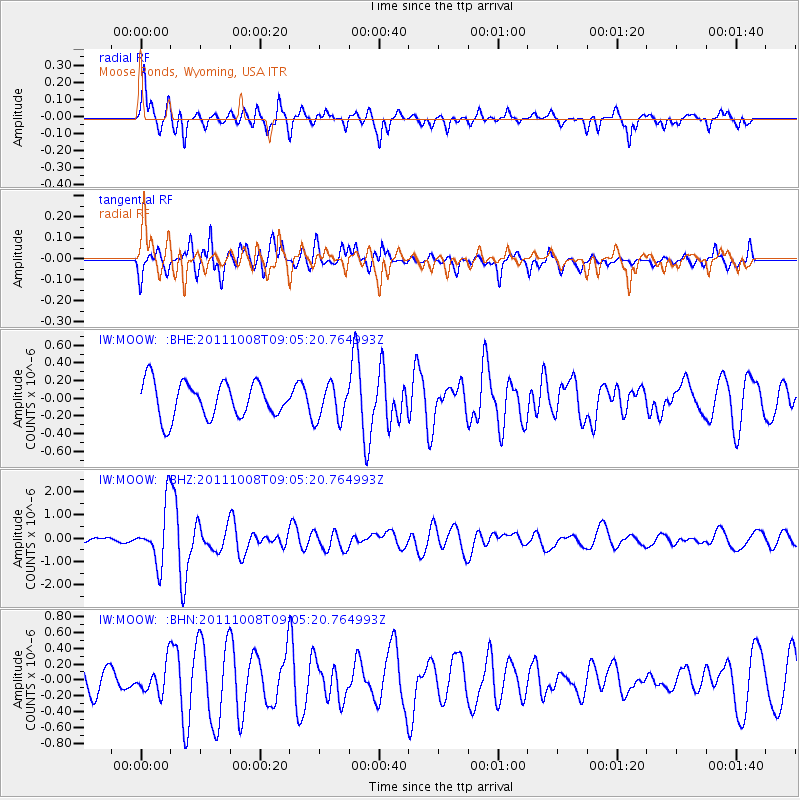
MOOW Moose Ponds, Wyoming, USA - Earthquake Result Viewer
*The percent match for this event was below the threshold and hence no stack was calculated.
| Earthquake location: |
Tonga Islands |
| Earthquake latitude/longitude: |
-20.6/-173.2 |
| Earthquake time(UTC): |
2011/10/08 (281) 08:53:11 GMT |
| Earthquake Depth: |
6.0 km |
| Earthquake Magnitude: |
6.1 MB, 5.6 MS, 5.9 MW, 5.9 MW |
| Earthquake Catalog/Contributor: |
WHDF/NEIC |
|
| Network: |
IW Intermountain West |
| Station: |
MOOW Moose Ponds, Wyoming, USA |
| Lat/Lon: |
43.75 N/110.74 W |
| Elevation: |
2128 m |
|
| Distance: |
85.8 deg |
| Az: |
40.12 deg |
| Baz: |
236.408 deg |
| Ray Param: |
$rayparam |
*The percent match for this event was below the threshold and hence was not used in the summary stack. |
|
| Radial Match: |
77.909386 % |
| Radial Bump: |
400 |
| Transverse Match: |
81.36415 % |
| Transverse Bump: |
400 |
| SOD ConfigId: |
424168 |
| Insert Time: |
2012-02-08 01:11:32.974 +0000 |
| GWidth: |
2.5 |
| Max Bumps: |
400 |
| Tol: |
0.001 |
|
Signal To Noise
| Channel | StoN | STA | LTA |
| IW:MOOW: :BHZ:20111008T09:05:20.764993Z | 8.379136 | 1.2185387E-6 | 1.4542533E-7 |
| IW:MOOW: :BHN:20111008T09:05:20.764993Z | 1.1575506 | 1.9061466E-7 | 1.646707E-7 |
| IW:MOOW: :BHE:20111008T09:05:20.764993Z | 1.0139267 | 2.0151163E-7 | 1.9874378E-7 |
| Arrivals |
| Ps | |
| PpPs | |
| PsPs/PpSs | |


