You are here: Home > Network List > TA - USArray Transportable Network (new EarthScope stations) Stations List
> Station Q24A Divide, CO, USA > Earthquake Result Viewer
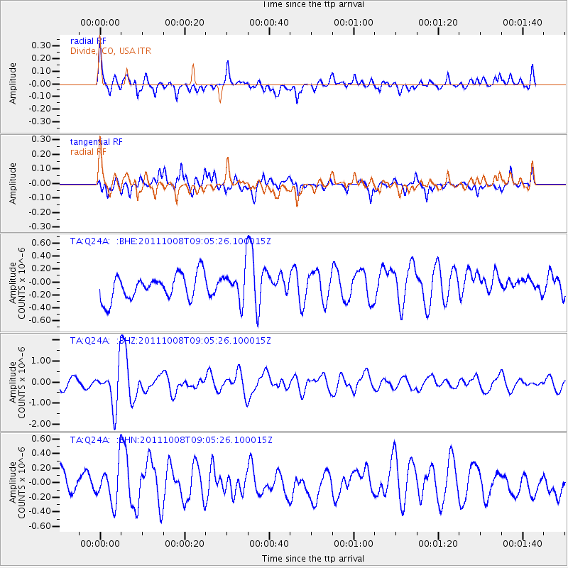
Q24A Divide, CO, USA - Earthquake Result Viewer
*The percent match for this event was below the threshold and hence no stack was calculated.
| Earthquake location: |
Tonga Islands |
| Earthquake latitude/longitude: |
-20.6/-173.2 |
| Earthquake time(UTC): |
2011/10/08 (281) 08:53:11 GMT |
| Earthquake Depth: |
6.0 km |
| Earthquake Magnitude: |
6.1 MB, 5.6 MS, 5.9 MW, 5.9 MW |
| Earthquake Catalog/Contributor: |
WHDF/NEIC |
|
| Network: |
TA USArray Transportable Network (new EarthScope stations) |
| Station: |
Q24A Divide, CO, USA |
| Lat/Lon: |
38.96 N/105.15 W |
| Elevation: |
2775 m |
|
| Distance: |
86.9 deg |
| Az: |
46.406 deg |
| Baz: |
240.494 deg |
| Ray Param: |
$rayparam |
*The percent match for this event was below the threshold and hence was not used in the summary stack. |
|
| Radial Match: |
69.52198 % |
| Radial Bump: |
400 |
| Transverse Match: |
63.92658 % |
| Transverse Bump: |
400 |
| SOD ConfigId: |
424168 |
| Insert Time: |
2012-02-08 01:15:34.321 +0000 |
| GWidth: |
2.5 |
| Max Bumps: |
400 |
| Tol: |
0.001 |
|
Signal To Noise
| Channel | StoN | STA | LTA |
| TA:Q24A: :BHZ:20111008T09:05:26.100015Z | 4.242441 | 9.908741E-7 | 2.3356225E-7 |
| TA:Q24A: :BHN:20111008T09:05:26.100015Z | 1.6052731 | 2.635541E-7 | 1.6418024E-7 |
| TA:Q24A: :BHE:20111008T09:05:26.100015Z | 1.3969836 | 2.684629E-7 | 1.9217326E-7 |
| Arrivals |
| Ps | |
| PpPs | |
| PsPs/PpSs | |


