You are here: Home > Network List > YB13 - Continental Dynamics/Cent. Anatolian Tectonics:Surface to Mantle Dynamics During Stations List
> Station AT18 Akbudak,Gaziantep,Turkey > Earthquake Result Viewer
AT18 Akbudak,Gaziantep,Turkey - Earthquake Result Viewer
| Earthquake location: |
E. Russia-N.E. China Border Reg. |
| Earthquake latitude/longitude: |
44.9/133.7 |
| Earthquake time(UTC): |
2014/04/12 (102) 21:22:44 GMT |
| Earthquake Depth: |
10 km |
| Earthquake Magnitude: |
4.3 mb |
| Earthquake Catalog/Contributor: |
ISC/ISC |
|
| Network: |
YB Continental Dynamics/Cent. Anatolian Tectonics:Surface to Mantle Dynamics During |
| Station: |
AT18 Akbudak,Gaziantep,Turkey |
| Lat/Lon: |
37.44 N/37.96 E |
| Elevation: |
546 m |
|
| Distance: |
68.3 deg |
| Az: |
301.549 deg |
| Baz: |
49.548 deg |
| Ray Param: |
0.05637782 |
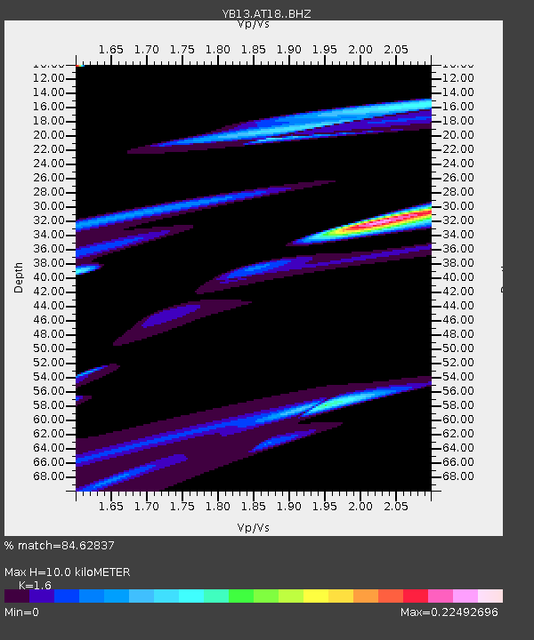
| Estimated Moho Depth: |
10.0 km |
| Estimated Crust Vp/Vs: |
1.60 |
| Assumed Crust Vp: |
6.247 km/s |
| Estimated Crust Vs: |
3.904 km/s |
| Estimated Crust Poisson's Ratio: |
0.18 |
|
| Radial Match: |
84.62837 % |
| Radial Bump: |
400 |
| Transverse Match: |
31.879276 % |
| Transverse Bump: |
150 |
| SOD ConfigId: |
3390531 |
| Insert Time: |
2019-04-11 08:22:13.468 +0000 |
| GWidth: |
2.5 |
| Max Bumps: |
400 |
| Tol: |
0.001 |
|

Signal To Noise
| Channel | StoN | STA | LTA |
| YB:AT18: :BHZ:20140412T21:33:14.63897Z | 0.9140855 | 1.4965987E-5 | 1.6372633E-5 |
| YB:AT18: :BHN:20140412T21:33:14.63897Z | 0.4663937 | 4.775349E-6 | 1.0238879E-5 |
| YB:AT18: :BHE:20140412T21:33:14.63897Z | 2.0867476 | 3.2109638E-5 | 1.5387408E-5 |
| Arrivals |
| Ps | 1.0 SECOND |
| PpPs | 4.0 SECOND |
| PsPs/PpSs | 5.0 SECOND |


