You are here: Home > Network List > CI - Caltech Regional Seismic Network Stations List
> Station LGU LGU, Camarillo, CA, USA > Earthquake Result Viewer
LGU LGU, Camarillo, CA, USA - Earthquake Result Viewer
| Earthquake location: |
Northern Chile |
| Earthquake latitude/longitude: |
-22.2/-69.9 |
| Earthquake time(UTC): |
2007/11/14 (318) 15:40:50 GMT |
| Earthquake Depth: |
40 km |
| Earthquake Magnitude: |
6.7 MB, 7.4 MS, 7.7 MW, 7.4 ME |
| Earthquake Catalog/Contributor: |
WHDF/NEIC |
|
| Network: |
CI Caltech Regional Seismic Network |
| Station: |
LGU LGU, Camarillo, CA, USA |
| Lat/Lon: |
34.11 N/119.07 W |
| Elevation: |
416 m |
|
| Distance: |
73.0 deg |
| Az: |
318.962 deg |
| Baz: |
132.853 deg |
| Ray Param: |
0.053227108 |
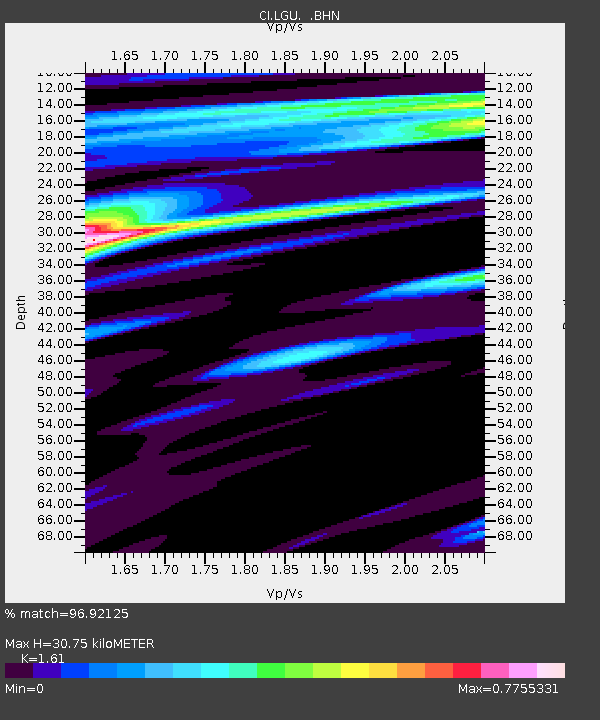
| Estimated Moho Depth: |
30.75 km |
| Estimated Crust Vp/Vs: |
1.61 |
| Assumed Crust Vp: |
6.1 km/s |
| Estimated Crust Vs: |
3.789 km/s |
| Estimated Crust Poisson's Ratio: |
0.19 |
|
| Radial Match: |
96.92125 % |
| Radial Bump: |
400 |
| Transverse Match: |
93.2303 % |
| Transverse Bump: |
400 |
| SOD ConfigId: |
2564 |
| Insert Time: |
2010-02-25 20:19:00.545 +0000 |
| GWidth: |
2.5 |
| Max Bumps: |
400 |
| Tol: |
0.001 |
|
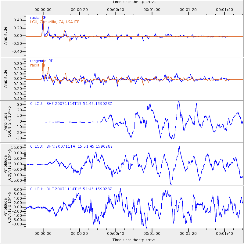
Signal To Noise
| Channel | StoN | STA | LTA |
| CI:LGU: :BHN:20071114T15:51:45.159028Z | 2.6369462 | 9.182102E-7 | 3.482097E-7 |
| CI:LGU: :BHE:20071114T15:51:45.159028Z | 2.3336031 | 9.1262405E-7 | 3.9107937E-7 |
| CI:LGU: :BHZ:20071114T15:51:45.159028Z | 11.835919 | 3.9445117E-6 | 3.332662E-7 |
| Arrivals |
| Ps | 3.2 SECOND |
| PpPs | 13 SECOND |
| PsPs/PpSs | 16 SECOND |


