You are here: Home > Network List > TA - USArray Transportable Network (new EarthScope stations) Stations List
> Station K32A Verdigre, NE, USA > Earthquake Result Viewer
K32A Verdigre, NE, USA - Earthquake Result Viewer

| Earthquake location: |
Tonga Islands |
| Earthquake latitude/longitude: |
-20.6/-173.2 |
| Earthquake time(UTC): |
2011/10/08 (281) 08:53:11 GMT |
| Earthquake Depth: |
6.0 km |
| Earthquake Magnitude: |
6.1 MB, 5.6 MS, 5.9 MW, 5.9 MW |
| Earthquake Catalog/Contributor: |
WHDF/NEIC |
|
| Network: |
TA USArray Transportable Network (new EarthScope stations) |
| Station: |
K32A Verdigre, NE, USA |
| Lat/Lon: |
42.66 N/97.97 W |
| Elevation: |
512 m |
|
| Distance: |
93.5 deg |
| Az: |
45.614 deg |
| Baz: |
245.175 deg |
| Ray Param: |
0.04125944 |
| Estimated Moho Depth: |
34.0 km |
| Estimated Crust Vp/Vs: |
1.77 |
| Assumed Crust Vp: |
6.498 km/s |
| Estimated Crust Vs: |
3.666 km/s |
| Estimated Crust Poisson's Ratio: |
0.27 |
|
| Radial Match: |
82.71174 % |
| Radial Bump: |
400 |
| Transverse Match: |
75.61744 % |
| Transverse Bump: |
400 |
| SOD ConfigId: |
424168 |
| Insert Time: |
2012-02-08 01:26:19.618 +0000 |
| GWidth: |
2.5 |
| Max Bumps: |
400 |
| Tol: |
0.001 |
|
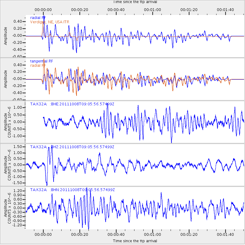
Signal To Noise
| Channel | StoN | STA | LTA |
| TA:K32A: :BHZ:20111008T09:05:56.57499Z | 6.586499 | 9.376517E-7 | 1.4235964E-7 |
| TA:K32A: :BHN:20111008T09:05:56.57499Z | 1.6292521 | 2.947439E-7 | 1.809075E-7 |
| TA:K32A: :BHE:20111008T09:05:56.57499Z | 2.0816925 | 4.6816314E-7 | 2.2489544E-7 |
| Arrivals |
| Ps | 4.1 SECOND |
| PpPs | 14 SECOND |
| PsPs/PpSs | 18 SECOND |


