You are here: Home > Network List > TA - USArray Transportable Network (new EarthScope stations) Stations List
> Station F31A Hecla, SD, USA > Earthquake Result Viewer
F31A Hecla, SD, USA - Earthquake Result Viewer
| Earthquake location: |
Tonga Islands |
| Earthquake latitude/longitude: |
-20.6/-173.2 |
| Earthquake time(UTC): |
2011/10/08 (281) 08:53:11 GMT |
| Earthquake Depth: |
6.0 km |
| Earthquake Magnitude: |
6.1 MB, 5.6 MS, 5.9 MW, 5.9 MW |
| Earthquake Catalog/Contributor: |
WHDF/NEIC |
|
| Network: |
TA USArray Transportable Network (new EarthScope stations) |
| Station: |
F31A Hecla, SD, USA |
| Lat/Lon: |
45.86 N/98.25 W |
| Elevation: |
412 m |
|
| Distance: |
94.6 deg |
| Az: |
42.618 deg |
| Baz: |
245.191 deg |
| Ray Param: |
0.04100358 |
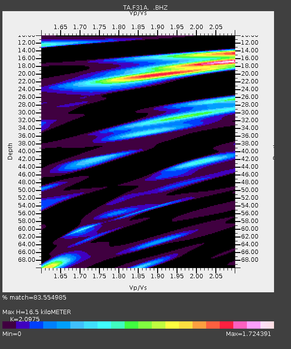
| Estimated Moho Depth: |
16.5 km |
| Estimated Crust Vp/Vs: |
2.10 |
| Assumed Crust Vp: |
6.53 km/s |
| Estimated Crust Vs: |
3.113 km/s |
| Estimated Crust Poisson's Ratio: |
0.35 |
|
| Radial Match: |
83.554985 % |
| Radial Bump: |
291 |
| Transverse Match: |
53.02758 % |
| Transverse Bump: |
366 |
| SOD ConfigId: |
424168 |
| Insert Time: |
2012-02-08 01:31:14.695 +0000 |
| GWidth: |
2.5 |
| Max Bumps: |
400 |
| Tol: |
0.001 |
|
Signal To Noise
| Channel | StoN | STA | LTA |
| TA:F31A: :BHZ:20111008T09:06:01.874978Z | 4.1443205 | 1.1687317E-6 | 2.8200807E-7 |
| TA:F31A: :BHN:20111008T09:06:01.874978Z | 2.0958915 | 6.583023E-7 | 3.1409178E-7 |
| TA:F31A: :BHE:20111008T09:06:01.874978Z | 4.32443 | 9.1493735E-7 | 2.1157409E-7 |
| Arrivals |
| Ps | 2.8 SECOND |
| PpPs | 7.7 SECOND |
| PsPs/PpSs | 11 SECOND |


