You are here: Home > Network List > TA - USArray Transportable Network (new EarthScope stations) Stations List
> Station T38A Diamond, MO, USA > Earthquake Result Viewer
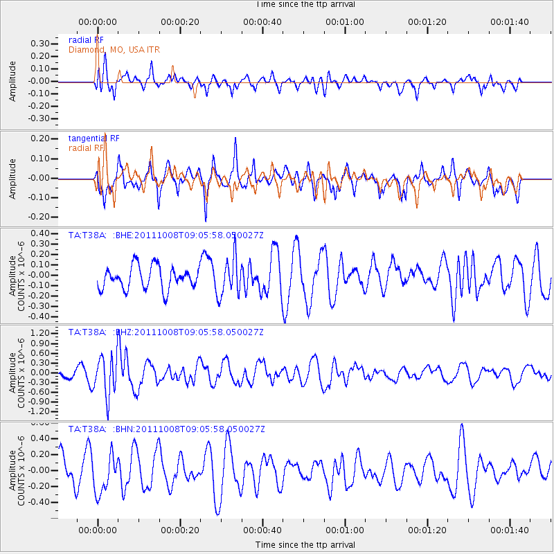
T38A Diamond, MO, USA - Earthquake Result Viewer
*The percent match for this event was below the threshold and hence no stack was calculated.
| Earthquake location: |
Tonga Islands |
| Earthquake latitude/longitude: |
-20.6/-173.2 |
| Earthquake time(UTC): |
2011/10/08 (281) 08:53:11 GMT |
| Earthquake Depth: |
6.0 km |
| Earthquake Magnitude: |
6.1 MB, 5.6 MS, 5.9 MW, 5.9 MW |
| Earthquake Catalog/Contributor: |
WHDF/NEIC |
|
| Network: |
TA USArray Transportable Network (new EarthScope stations) |
| Station: |
T38A Diamond, MO, USA |
| Lat/Lon: |
37.04 N/94.29 W |
| Elevation: |
349 m |
|
| Distance: |
93.8 deg |
| Az: |
51.908 deg |
| Baz: |
247.13 deg |
| Ray Param: |
$rayparam |
*The percent match for this event was below the threshold and hence was not used in the summary stack. |
|
| Radial Match: |
62.099865 % |
| Radial Bump: |
400 |
| Transverse Match: |
65.78602 % |
| Transverse Bump: |
400 |
| SOD ConfigId: |
424168 |
| Insert Time: |
2012-02-08 01:36:19.450 +0000 |
| GWidth: |
2.5 |
| Max Bumps: |
400 |
| Tol: |
0.001 |
|
Signal To Noise
| Channel | StoN | STA | LTA |
| TA:T38A: :BHZ:20111008T09:05:58.050027Z | 3.7480462 | 6.165249E-7 | 1.6449235E-7 |
| TA:T38A: :BHN:20111008T09:05:58.050027Z | 1.7620654 | 2.4069803E-7 | 1.3659994E-7 |
| TA:T38A: :BHE:20111008T09:05:58.050027Z | 1.6989356 | 1.8530076E-7 | 1.09068736E-7 |
| Arrivals |
| Ps | |
| PpPs | |
| PsPs/PpSs | |


