You are here: Home > Network List > TA - USArray Transportable Network (new EarthScope stations) Stations List
> Station Y42A Garnett, Star City, AR, USA > Earthquake Result Viewer
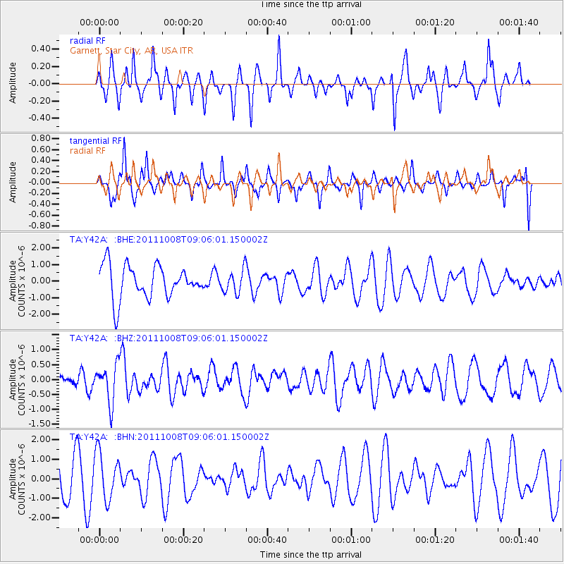
Y42A Garnett, Star City, AR, USA - Earthquake Result Viewer
*The percent match for this event was below the threshold and hence no stack was calculated.
| Earthquake location: |
Tonga Islands |
| Earthquake latitude/longitude: |
-20.6/-173.2 |
| Earthquake time(UTC): |
2011/10/08 (281) 08:53:11 GMT |
| Earthquake Depth: |
6.0 km |
| Earthquake Magnitude: |
6.1 MB, 5.6 MS, 5.9 MW, 5.9 MW |
| Earthquake Catalog/Contributor: |
WHDF/NEIC |
|
| Network: |
TA USArray Transportable Network (new EarthScope stations) |
| Station: |
Y42A Garnett, Star City, AR, USA |
| Lat/Lon: |
33.84 N/91.79 W |
| Elevation: |
77 m |
|
| Distance: |
94.5 deg |
| Az: |
55.646 deg |
| Baz: |
248.308 deg |
| Ray Param: |
$rayparam |
*The percent match for this event was below the threshold and hence was not used in the summary stack. |
|
| Radial Match: |
55.668575 % |
| Radial Bump: |
292 |
| Transverse Match: |
61.66659 % |
| Transverse Bump: |
317 |
| SOD ConfigId: |
424168 |
| Insert Time: |
2012-02-08 01:38:14.273 +0000 |
| GWidth: |
2.5 |
| Max Bumps: |
400 |
| Tol: |
0.001 |
|
Signal To Noise
| Channel | StoN | STA | LTA |
| TA:Y42A: :BHZ:20111008T09:06:01.150002Z | 3.2861044 | 6.613597E-7 | 2.012595E-7 |
| TA:Y42A: :BHN:20111008T09:06:01.150002Z | 1.542672 | 1.2169007E-6 | 7.888265E-7 |
| TA:Y42A: :BHE:20111008T09:06:01.150002Z | 0.7119284 | 7.121095E-7 | 1.0002543E-6 |
| Arrivals |
| Ps | |
| PpPs | |
| PsPs/PpSs | |


