You are here: Home > Network List > UW - Pacific Northwest Regional Seismic Network Stations List
> Station TAKO Tahkenitch, OR CREST BB SMO > Earthquake Result Viewer
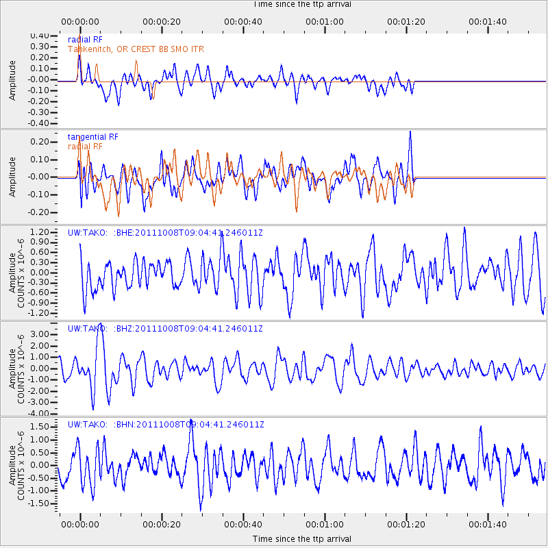
TAKO Tahkenitch, OR CREST BB SMO - Earthquake Result Viewer
*The percent match for this event was below the threshold and hence no stack was calculated.
| Earthquake location: |
Tonga Islands |
| Earthquake latitude/longitude: |
-20.6/-173.2 |
| Earthquake time(UTC): |
2011/10/08 (281) 08:53:11 GMT |
| Earthquake Depth: |
6.0 km |
| Earthquake Magnitude: |
6.1 MB, 5.6 MS, 5.9 MW, 5.9 MW |
| Earthquake Catalog/Contributor: |
WHDF/NEIC |
|
| Network: |
UW Pacific Northwest Regional Seismic Network |
| Station: |
TAKO Tahkenitch, OR CREST BB SMO |
| Lat/Lon: |
43.74 N/124.08 W |
| Elevation: |
46 m |
|
| Distance: |
78.3 deg |
| Az: |
34.043 deg |
| Baz: |
226.354 deg |
| Ray Param: |
$rayparam |
*The percent match for this event was below the threshold and hence was not used in the summary stack. |
|
| Radial Match: |
54.982674 % |
| Radial Bump: |
400 |
| Transverse Match: |
51.48055 % |
| Transverse Bump: |
400 |
| SOD ConfigId: |
424168 |
| Insert Time: |
2012-02-08 01:42:50.209 +0000 |
| GWidth: |
2.5 |
| Max Bumps: |
400 |
| Tol: |
0.001 |
|
Signal To Noise
| Channel | StoN | STA | LTA |
| UW:TAKO: :BHZ:20111008T09:04:41.246011Z | 3.213646 | 1.8066596E-6 | 5.621838E-7 |
| UW:TAKO: :BHN:20111008T09:04:41.246011Z | 1.2158786 | 7.603723E-7 | 6.253686E-7 |
| UW:TAKO: :BHE:20111008T09:04:41.246011Z | 1.2724603 | 4.8602243E-7 | 3.819549E-7 |
| Arrivals |
| Ps | |
| PpPs | |
| PsPs/PpSs | |


