You are here: Home > Network List > UW - Pacific Northwest Regional Seismic Network Stations List
> Station YACT Amboy, WA, USA > Earthquake Result Viewer
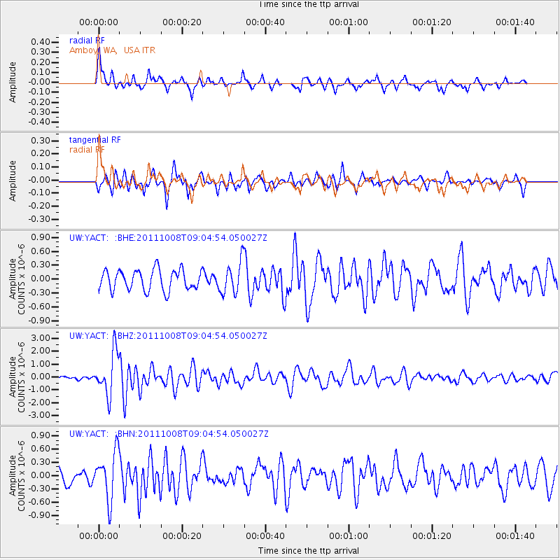
YACT Amboy, WA, USA - Earthquake Result Viewer
*The percent match for this event was below the threshold and hence no stack was calculated.
| Earthquake location: |
Tonga Islands |
| Earthquake latitude/longitude: |
-20.6/-173.2 |
| Earthquake time(UTC): |
2011/10/08 (281) 08:53:11 GMT |
| Earthquake Depth: |
6.0 km |
| Earthquake Magnitude: |
6.1 MB, 5.6 MS, 5.9 MW, 5.9 MW |
| Earthquake Catalog/Contributor: |
WHDF/NEIC |
|
| Network: |
UW Pacific Northwest Regional Seismic Network |
| Station: |
YACT Amboy, WA, USA |
| Lat/Lon: |
45.93 N/122.42 W |
| Elevation: |
211 m |
|
| Distance: |
80.6 deg |
| Az: |
33.241 deg |
| Baz: |
227.376 deg |
| Ray Param: |
$rayparam |
*The percent match for this event was below the threshold and hence was not used in the summary stack. |
|
| Radial Match: |
75.93423 % |
| Radial Bump: |
352 |
| Transverse Match: |
73.086914 % |
| Transverse Bump: |
351 |
| SOD ConfigId: |
424168 |
| Insert Time: |
2012-02-08 01:43:03.048 +0000 |
| GWidth: |
2.5 |
| Max Bumps: |
400 |
| Tol: |
0.001 |
|
Signal To Noise
| Channel | StoN | STA | LTA |
| UW:YACT: :BHZ:20111008T09:04:54.050027Z | 9.463395 | 1.714548E-6 | 1.8117683E-7 |
| UW:YACT: :BHN:20111008T09:04:54.050027Z | 3.5951777 | 5.558677E-7 | 1.5461481E-7 |
| UW:YACT: :BHE:20111008T09:04:54.050027Z | 1.6221117 | 3.572304E-7 | 2.2022552E-7 |
| Arrivals |
| Ps | |
| PpPs | |
| PsPs/PpSs | |


