You are here: Home > Network List > AU - Australian Seismological Centre Stations List
> Station CMSA Cobar, New South Wales > Earthquake Result Viewer
CMSA Cobar, New South Wales - Earthquake Result Viewer
| Earthquake location: |
South Of Bali, Indonesia |
| Earthquake latitude/longitude: |
-9.4/114.6 |
| Earthquake time(UTC): |
2011/10/13 (286) 03:16:30 GMT |
| Earthquake Depth: |
39 km |
| Earthquake Magnitude: |
6.1 MB, 6.0 MS, 6.2 MW, 6.1 MW |
| Earthquake Catalog/Contributor: |
WHDF/NEIC |
|
| Network: |
AU Australian Seismological Centre |
| Station: |
CMSA Cobar, New South Wales |
| Lat/Lon: |
31.54 S/145.69 E |
| Elevation: |
220 m |
|
| Distance: |
36.3 deg |
| Az: |
131.893 deg |
| Baz: |
300.641 deg |
| Ray Param: |
0.07665171 |
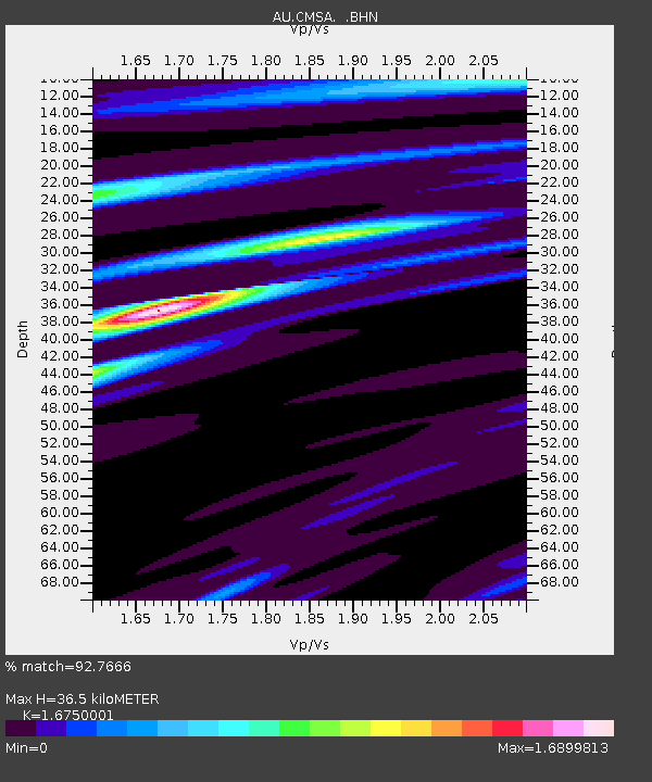
| Estimated Moho Depth: |
36.5 km |
| Estimated Crust Vp/Vs: |
1.68 |
| Assumed Crust Vp: |
6.522 km/s |
| Estimated Crust Vs: |
3.894 km/s |
| Estimated Crust Poisson's Ratio: |
0.22 |
|
| Radial Match: |
92.7666 % |
| Radial Bump: |
259 |
| Transverse Match: |
71.17759 % |
| Transverse Bump: |
400 |
| SOD ConfigId: |
424168 |
| Insert Time: |
2012-02-08 02:05:18.032 +0000 |
| GWidth: |
2.5 |
| Max Bumps: |
400 |
| Tol: |
0.001 |
|

Signal To Noise
| Channel | StoN | STA | LTA |
| AU:CMSA: :BHZ:20111013T03:22:59.969998Z | 18.490156 | 3.5222467E-6 | 1.9049308E-7 |
| AU:CMSA: :BHN:20111013T03:22:59.969998Z | 6.587465 | 1.2577513E-6 | 1.90931E-7 |
| AU:CMSA: :BHE:20111013T03:22:59.969998Z | 7.6321716 | 1.8834191E-6 | 2.467737E-7 |
| Arrivals |
| Ps | 4.1 SECOND |
| PpPs | 14 SECOND |
| PsPs/PpSs | 18 SECOND |


