You are here: Home > Network List > AU - Australian Seismological Centre Stations List
> Station CNB Kowen Forrest, Australian Capital Territory > Earthquake Result Viewer
CNB Kowen Forrest, Australian Capital Territory - Earthquake Result Viewer
| Earthquake location: |
South Of Bali, Indonesia |
| Earthquake latitude/longitude: |
-9.4/114.6 |
| Earthquake time(UTC): |
2011/10/13 (286) 03:16:30 GMT |
| Earthquake Depth: |
39 km |
| Earthquake Magnitude: |
6.1 MB, 6.0 MS, 6.2 MW, 6.1 MW |
| Earthquake Catalog/Contributor: |
WHDF/NEIC |
|
| Network: |
AU Australian Seismological Centre |
| Station: |
CNB Kowen Forrest, Australian Capital Territory |
| Lat/Lon: |
35.31 S/149.36 E |
| Elevation: |
853 m |
|
| Distance: |
40.9 deg |
| Az: |
134.571 deg |
| Baz: |
300.721 deg |
| Ray Param: |
0.07403569 |
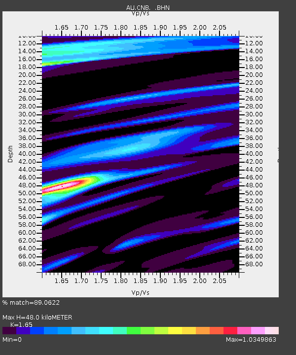
| Estimated Moho Depth: |
48.0 km |
| Estimated Crust Vp/Vs: |
1.65 |
| Assumed Crust Vp: |
6.633 km/s |
| Estimated Crust Vs: |
4.02 km/s |
| Estimated Crust Poisson's Ratio: |
0.21 |
|
| Radial Match: |
89.0622 % |
| Radial Bump: |
270 |
| Transverse Match: |
67.093285 % |
| Transverse Bump: |
369 |
| SOD ConfigId: |
424168 |
| Insert Time: |
2012-02-08 02:06:00.613 +0000 |
| GWidth: |
2.5 |
| Max Bumps: |
400 |
| Tol: |
0.001 |
|

Signal To Noise
| Channel | StoN | STA | LTA |
| AU:CNB: :BHZ:20111013T03:23:38.17001Z | 10.9920025 | 2.5135823E-6 | 2.2867374E-7 |
| AU:CNB: :BHN:20111013T03:23:38.17001Z | 7.1596475 | 1.1154417E-6 | 1.5579562E-7 |
| AU:CNB: :BHE:20111013T03:23:38.17001Z | 5.8503947 | 1.2842177E-6 | 2.1950957E-7 |
| Arrivals |
| Ps | 5.1 SECOND |
| PpPs | 18 SECOND |
| PsPs/PpSs | 23 SECOND |


