You are here: Home > Network List > IW - Intermountain West Stations List
> Station TPAW Teton Pass, Wyoming, USA > Earthquake Result Viewer
TPAW Teton Pass, Wyoming, USA - Earthquake Result Viewer
| Earthquake location: |
Solomon Islands |
| Earthquake latitude/longitude: |
-11.7/162.8 |
| Earthquake time(UTC): |
2014/04/12 (102) 23:07:18 GMT |
| Earthquake Depth: |
0.0 km |
| Earthquake Magnitude: |
4.2 mb |
| Earthquake Catalog/Contributor: |
ISC/ISC |
|
| Network: |
IW Intermountain West |
| Station: |
TPAW Teton Pass, Wyoming, USA |
| Lat/Lon: |
43.49 N/110.95 W |
| Elevation: |
2512 m |
|
| Distance: |
95.3 deg |
| Az: |
46.829 deg |
| Baz: |
258.943 deg |
| Ray Param: |
0.040833373 |
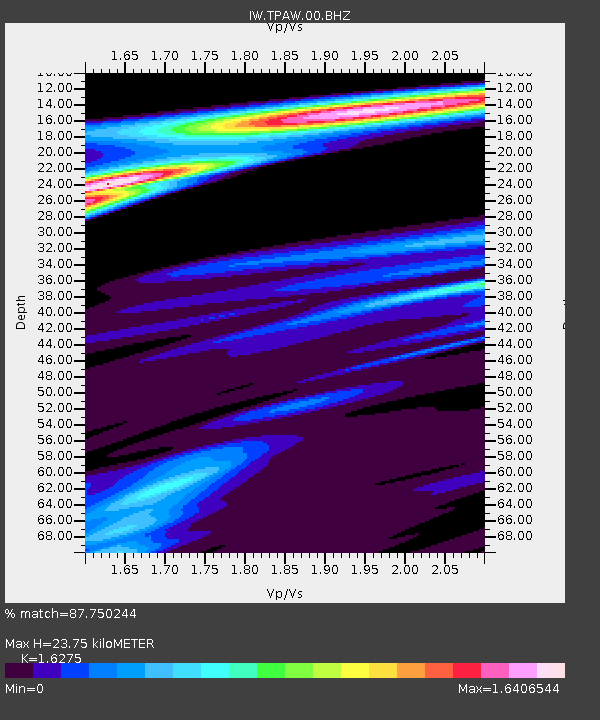
| Estimated Moho Depth: |
23.75 km |
| Estimated Crust Vp/Vs: |
1.63 |
| Assumed Crust Vp: |
6.207 km/s |
| Estimated Crust Vs: |
3.814 km/s |
| Estimated Crust Poisson's Ratio: |
0.20 |
|
| Radial Match: |
87.750244 % |
| Radial Bump: |
352 |
| Transverse Match: |
52.25112 % |
| Transverse Bump: |
400 |
| SOD ConfigId: |
3390531 |
| Insert Time: |
2019-04-11 08:29:36.696 +0000 |
| GWidth: |
2.5 |
| Max Bumps: |
400 |
| Tol: |
0.001 |
|

Signal To Noise
| Channel | StoN | STA | LTA |
| IW:TPAW:00:BHZ:20140412T23:20:12.765Z | 0.68784606 | 8.639482E-7 | 1.2560197E-6 |
| IW:TPAW:00:BH1:20140412T23:20:12.765Z | 1.5498843 | 9.176111E-7 | 5.920513E-7 |
| IW:TPAW:00:BH2:20140412T23:20:12.765Z | 1.8407893 | 1.4033373E-6 | 7.6235625E-7 |
| Arrivals |
| Ps | 2.5 SECOND |
| PpPs | 9.9 SECOND |
| PsPs/PpSs | 12 SECOND |


