You are here: Home > Network List > G - GEOSCOPE Stations List
> Station FDF Fort de France, Martinique France > Earthquake Result Viewer
FDF Fort de France, Martinique France - Earthquake Result Viewer
| Earthquake location: |
Michoacan, Mexico |
| Earthquake latitude/longitude: |
18.2/-102.5 |
| Earthquake time(UTC): |
2000/08/09 (222) 11:41:47 GMT |
| Earthquake Depth: |
46 km |
| Earthquake Magnitude: |
6.1 MB, 6.5 MS, 6.5 MW, 6.4 MW |
| Earthquake Catalog/Contributor: |
WHDF/NEIC |
|
| Network: |
G GEOSCOPE |
| Station: |
FDF Fort de France, Martinique France |
| Lat/Lon: |
14.73 N/61.14 W |
| Elevation: |
467 m |
|
| Distance: |
39.7 deg |
| Az: |
88.676 deg |
| Baz: |
280.814 deg |
| Ray Param: |
0.07469585 |
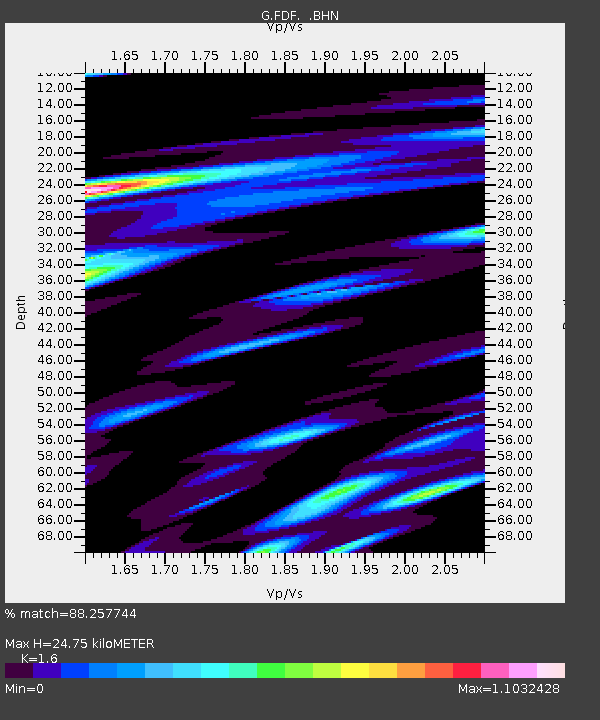
| Estimated Moho Depth: |
24.75 km |
| Estimated Crust Vp/Vs: |
1.60 |
| Assumed Crust Vp: |
5.88 km/s |
| Estimated Crust Vs: |
3.675 km/s |
| Estimated Crust Poisson's Ratio: |
0.18 |
|
| Radial Match: |
88.257744 % |
| Radial Bump: |
400 |
| Transverse Match: |
64.86664 % |
| Transverse Bump: |
400 |
| SOD ConfigId: |
3744 |
| Insert Time: |
2010-02-26 22:32:40.607 +0000 |
| GWidth: |
2.5 |
| Max Bumps: |
400 |
| Tol: |
0.001 |
|
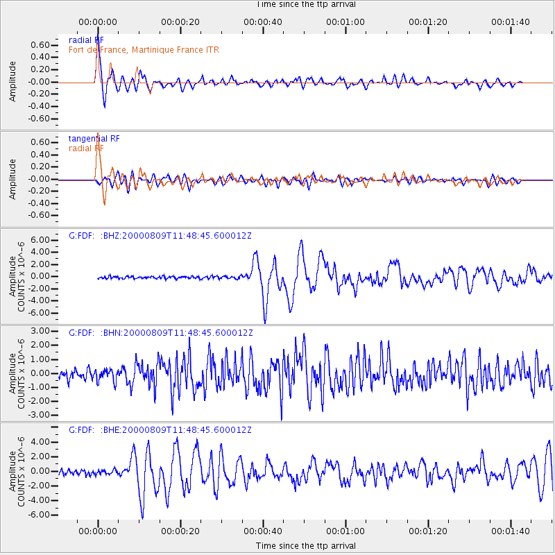
Signal To Noise
| Channel | StoN | STA | LTA |
| G:FDF: :BHN:20000809T11:48:45.600012Z | 1.4172876 | 4.204965E-7 | 2.96691E-7 |
| G:FDF: :BHE:20000809T11:48:45.600012Z | 0.9886469 | 2.872984E-7 | 2.905976E-7 |
| G:FDF: :BHZ:20000809T11:48:45.600012Z | 1.2756448 | 2.0604406E-7 | 1.6152151E-7 |
| Arrivals |
| Ps | 2.7 SECOND |
| PpPs | 10 SECOND |
| PsPs/PpSs | 13 SECOND |


