You are here: Home > Network List > US - United States National Seismic Network Stations List
> Station MSO Missoula, Montana, USA > Earthquake Result Viewer
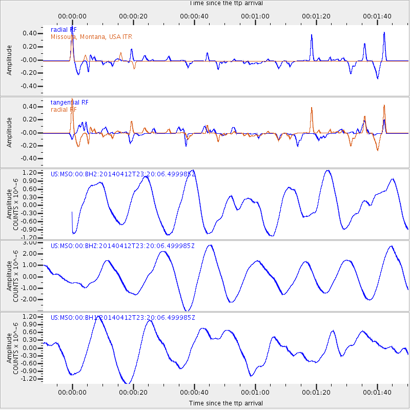
MSO Missoula, Montana, USA - Earthquake Result Viewer
*The percent match for this event was below the threshold and hence no stack was calculated.
| Earthquake location: |
Solomon Islands |
| Earthquake latitude/longitude: |
-11.7/162.8 |
| Earthquake time(UTC): |
2014/04/12 (102) 23:07:18 GMT |
| Earthquake Depth: |
0.0 km |
| Earthquake Magnitude: |
4.2 mb |
| Earthquake Catalog/Contributor: |
ISC/ISC |
|
| Network: |
US United States National Seismic Network |
| Station: |
MSO Missoula, Montana, USA |
| Lat/Lon: |
46.83 N/113.94 W |
| Elevation: |
1264 m |
|
| Distance: |
93.9 deg |
| Az: |
43.113 deg |
| Baz: |
257.126 deg |
| Ray Param: |
$rayparam |
*The percent match for this event was below the threshold and hence was not used in the summary stack. |
|
| Radial Match: |
53.589863 % |
| Radial Bump: |
400 |
| Transverse Match: |
66.20643 % |
| Transverse Bump: |
400 |
| SOD ConfigId: |
3390531 |
| Insert Time: |
2019-04-11 08:31:19.779 +0000 |
| GWidth: |
2.5 |
| Max Bumps: |
400 |
| Tol: |
0.001 |
|
Signal To Noise
| Channel | StoN | STA | LTA |
| US:MSO:00:BHZ:20140412T23:20:06.499985Z | 0.70669556 | 8.550137E-7 | 1.2098756E-6 |
| US:MSO:00:BH1:20140412T23:20:06.499985Z | 2.4534762 | 9.828293E-7 | 4.0058643E-7 |
| US:MSO:00:BH2:20140412T23:20:06.499985Z | 1.5833308 | 1.0055917E-6 | 6.351116E-7 |
| Arrivals |
| Ps | |
| PpPs | |
| PsPs/PpSs | |


