You are here: Home > Network List > G - GEOSCOPE Stations List
> Station FDF Fort de France, Martinique France > Earthquake Result Viewer
FDF Fort de France, Martinique France - Earthquake Result Viewer

| Earthquake location: |
Iceland |
| Earthquake latitude/longitude: |
64.0/-20.5 |
| Earthquake time(UTC): |
2000/06/17 (169) 15:40:41 GMT |
| Earthquake Depth: |
10 km |
| Earthquake Magnitude: |
5.7 MB, 6.6 MS, 6.8 MW, 6.5 MW |
| Earthquake Catalog/Contributor: |
WHDF/NEIC |
|
| Network: |
G GEOSCOPE |
| Station: |
FDF Fort de France, Martinique France |
| Lat/Lon: |
14.73 N/61.14 W |
| Elevation: |
467 m |
|
| Distance: |
56.6 deg |
| Az: |
229.043 deg |
| Baz: |
20.148 deg |
| Ray Param: |
0.06404708 |
| Estimated Moho Depth: |
25.0 km |
| Estimated Crust Vp/Vs: |
1.73 |
| Assumed Crust Vp: |
5.88 km/s |
| Estimated Crust Vs: |
3.394 km/s |
| Estimated Crust Poisson's Ratio: |
0.25 |
|
| Radial Match: |
80.35519 % |
| Radial Bump: |
400 |
| Transverse Match: |
80.7974 % |
| Transverse Bump: |
400 |
| SOD ConfigId: |
3744 |
| Insert Time: |
2010-02-26 22:32:42.177 +0000 |
| GWidth: |
2.5 |
| Max Bumps: |
400 |
| Tol: |
0.001 |
|
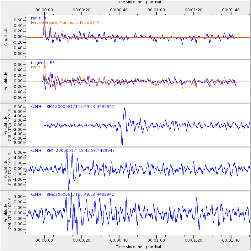
Signal To Noise
| Channel | StoN | STA | LTA |
| G:FDF: :BHN:20000617T15:49:53.448994Z | 0.7746567 | 4.862952E-7 | 6.2775575E-7 |
| G:FDF: :BHE:20000617T15:49:53.448994Z | 1.2093365 | 7.2353754E-7 | 5.98293E-7 |
| G:FDF: :BHZ:20000617T15:49:53.448994Z | 1.3876637 | 5.022866E-7 | 3.6196562E-7 |
| Arrivals |
| Ps | 3.3 SECOND |
| PpPs | 11 SECOND |
| PsPs/PpSs | 14 SECOND |


