You are here: Home > Network List > TA - USArray Transportable Network (new EarthScope stations) Stations List
> Station N59A State Game Land 141, Hazleton, PA, USA > Earthquake Result Viewer
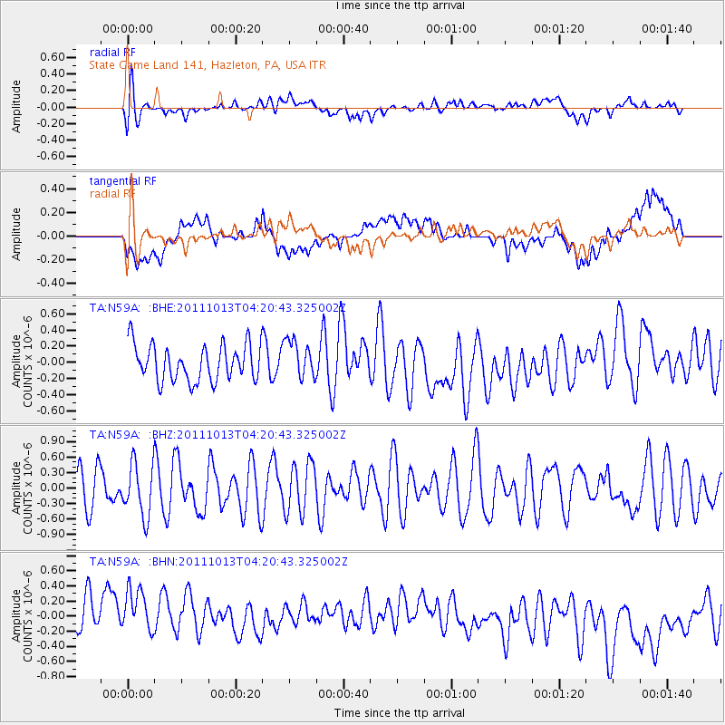
N59A State Game Land 141, Hazleton, PA, USA - Earthquake Result Viewer
*The percent match for this event was below the threshold and hence no stack was calculated.
| Earthquake location: |
Off Coast Of Oregon |
| Earthquake latitude/longitude: |
43.5/-127.1 |
| Earthquake time(UTC): |
2011/10/13 (286) 04:14:00 GMT |
| Earthquake Depth: |
21 km |
| Earthquake Magnitude: |
5.6 MW, 5.0 MS, 5.4 MB |
| Earthquake Catalog/Contributor: |
WHDF/NEIC |
|
| Network: |
TA USArray Transportable Network (new EarthScope stations) |
| Station: |
N59A State Game Land 141, Hazleton, PA, USA |
| Lat/Lon: |
40.92 N/75.77 W |
| Elevation: |
508 m |
|
| Distance: |
37.7 deg |
| Az: |
75.713 deg |
| Baz: |
291.394 deg |
| Ray Param: |
$rayparam |
*The percent match for this event was below the threshold and hence was not used in the summary stack. |
|
| Radial Match: |
56.93378 % |
| Radial Bump: |
400 |
| Transverse Match: |
44.96266 % |
| Transverse Bump: |
400 |
| SOD ConfigId: |
424168 |
| Insert Time: |
2012-02-08 02:17:01.486 +0000 |
| GWidth: |
2.5 |
| Max Bumps: |
400 |
| Tol: |
0.001 |
|
Signal To Noise
| Channel | StoN | STA | LTA |
| TA:N59A: :BHZ:20111013T04:20:43.325002Z | 1.2031518 | 5.1342494E-7 | 4.2673327E-7 |
| TA:N59A: :BHN:20111013T04:20:43.325002Z | 1.1930177 | 5.287041E-7 | 4.4316536E-7 |
| TA:N59A: :BHE:20111013T04:20:43.325002Z | 1.0469086 | 2.3292175E-7 | 2.2248528E-7 |
| Arrivals |
| Ps | |
| PpPs | |
| PsPs/PpSs | |


