You are here: Home > Network List > TA - USArray Transportable Network (new EarthScope stations) Stations List
> Station Y46A Houston, MS, USA > Earthquake Result Viewer
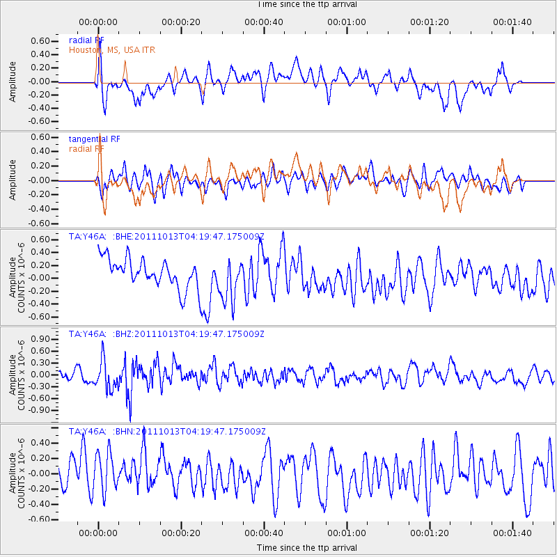
Y46A Houston, MS, USA - Earthquake Result Viewer
*The percent match for this event was below the threshold and hence no stack was calculated.
| Earthquake location: |
Off Coast Of Oregon |
| Earthquake latitude/longitude: |
43.5/-127.1 |
| Earthquake time(UTC): |
2011/10/13 (286) 04:14:00 GMT |
| Earthquake Depth: |
21 km |
| Earthquake Magnitude: |
5.6 MW, 5.0 MS, 5.4 MB |
| Earthquake Catalog/Contributor: |
WHDF/NEIC |
|
| Network: |
TA USArray Transportable Network (new EarthScope stations) |
| Station: |
Y46A Houston, MS, USA |
| Lat/Lon: |
33.88 N/88.86 W |
| Elevation: |
109 m |
|
| Distance: |
31.1 deg |
| Az: |
94.834 deg |
| Baz: |
299.291 deg |
| Ray Param: |
$rayparam |
*The percent match for this event was below the threshold and hence was not used in the summary stack. |
|
| Radial Match: |
60.299644 % |
| Radial Bump: |
400 |
| Transverse Match: |
56.353943 % |
| Transverse Bump: |
400 |
| SOD ConfigId: |
424168 |
| Insert Time: |
2012-02-08 02:17:39.295 +0000 |
| GWidth: |
2.5 |
| Max Bumps: |
400 |
| Tol: |
0.001 |
|
Signal To Noise
| Channel | StoN | STA | LTA |
| TA:Y46A: :BHZ:20111013T04:19:47.175009Z | 2.6992111 | 3.7330128E-7 | 1.3830014E-7 |
| TA:Y46A: :BHN:20111013T04:19:47.175009Z | 1.1242453 | 2.970871E-7 | 2.642547E-7 |
| TA:Y46A: :BHE:20111013T04:19:47.175009Z | 1.5308307 | 3.4222865E-7 | 2.2355748E-7 |
| Arrivals |
| Ps | |
| PpPs | |
| PsPs/PpSs | |


