You are here: Home > Network List > G - GEOSCOPE Stations List
> Station FDF Fort de France, Martinique France > Earthquake Result Viewer
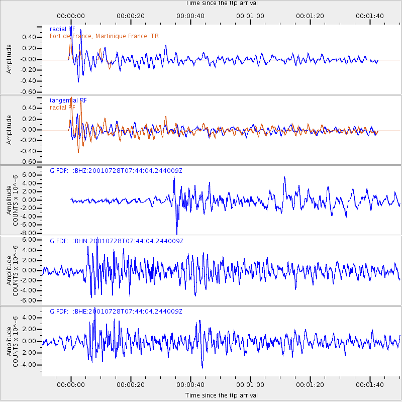
FDF Fort de France, Martinique France - Earthquake Result Viewer

| Earthquake location: |
Southern Alaska |
| Earthquake latitude/longitude: |
59.0/-155.1 |
| Earthquake time(UTC): |
2001/07/28 (209) 07:32:43 GMT |
| Earthquake Depth: |
131 km |
| Earthquake Magnitude: |
5.7 MB, 5.7 MS, 6.6 MW, 6.2 ME |
| Earthquake Catalog/Contributor: |
WHDF/NEIC |
|
| Network: |
G GEOSCOPE |
| Station: |
FDF Fort de France, Martinique France |
| Lat/Lon: |
14.73 N/61.14 W |
| Elevation: |
467 m |
|
| Distance: |
79.5 deg |
| Az: |
78.972 deg |
| Baz: |
328.352 deg |
| Ray Param: |
0.048586488 |
| Estimated Moho Depth: |
24.5 km |
| Estimated Crust Vp/Vs: |
1.80 |
| Assumed Crust Vp: |
5.88 km/s |
| Estimated Crust Vs: |
3.271 km/s |
| Estimated Crust Poisson's Ratio: |
0.28 |
|
| Radial Match: |
80.089905 % |
| Radial Bump: |
400 |
| Transverse Match: |
67.84465 % |
| Transverse Bump: |
400 |
| SOD ConfigId: |
20082 |
| Insert Time: |
2010-02-26 22:32:47.185 +0000 |
| GWidth: |
2.5 |
| Max Bumps: |
400 |
| Tol: |
0.001 |
|
Signal To Noise
| Channel | StoN | STA | LTA |
| G:FDF: :BHN:20010728T07:44:04.244009Z | 1.5413976 | 7.6495917E-7 | 4.9627636E-7 |
| G:FDF: :BHE:20010728T07:44:04.244009Z | 1.4976243 | 6.358713E-7 | 4.2458663E-7 |
| G:FDF: :BHZ:20010728T07:44:04.244009Z | 4.9270535 | 1.4343134E-6 | 2.9110979E-7 |
| Arrivals |
| Ps | 3.4 SECOND |
| PpPs | 11 SECOND |
| PsPs/PpSs | 15 SECOND |


