You are here: Home > Network List > AK - Alaska Regional Network Stations List
> Station GOAT Goat Mountain, AK, USA > Earthquake Result Viewer
GOAT Goat Mountain, AK, USA - Earthquake Result Viewer
| Earthquake location: |
Solomon Islands |
| Earthquake latitude/longitude: |
-11.4/162.5 |
| Earthquake time(UTC): |
2014/04/12 (102) 23:52:15 GMT |
| Earthquake Depth: |
12 km |
| Earthquake Magnitude: |
5.0 mb |
| Earthquake Catalog/Contributor: |
ISC/ISC |
|
| Network: |
AK Alaska Regional Network |
| Station: |
GOAT Goat Mountain, AK, USA |
| Lat/Lon: |
60.58 N/144.73 W |
| Elevation: |
896 m |
|
| Distance: |
83.0 deg |
| Az: |
23.321 deg |
| Baz: |
231.841 deg |
| Ray Param: |
0.046522804 |
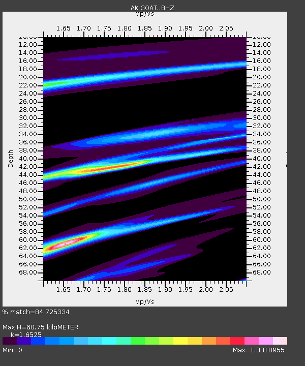
| Estimated Moho Depth: |
60.75 km |
| Estimated Crust Vp/Vs: |
1.65 |
| Assumed Crust Vp: |
6.566 km/s |
| Estimated Crust Vs: |
3.973 km/s |
| Estimated Crust Poisson's Ratio: |
0.21 |
|
| Radial Match: |
84.725334 % |
| Radial Bump: |
396 |
| Transverse Match: |
72.071976 % |
| Transverse Bump: |
400 |
| SOD ConfigId: |
3390531 |
| Insert Time: |
2019-04-11 08:32:30.608 +0000 |
| GWidth: |
2.5 |
| Max Bumps: |
400 |
| Tol: |
0.001 |
|

Signal To Noise
| Channel | StoN | STA | LTA |
| AK:GOAT: :BHZ:20140413T00:04:09.148025Z | 2.3088543 | 1.0405226E-6 | 4.5066622E-7 |
| AK:GOAT: :BHN:20140413T00:04:09.148025Z | 1.2042558 | 3.4006607E-7 | 2.823869E-7 |
| AK:GOAT: :BHE:20140413T00:04:09.148025Z | 1.1143001 | 2.7769877E-7 | 2.4921363E-7 |
| Arrivals |
| Ps | 6.2 SECOND |
| PpPs | 24 SECOND |
| PsPs/PpSs | 30 SECOND |


