You are here: Home > Network List > G - GEOSCOPE Stations List
> Station FDF Fort de France, Martinique France > Earthquake Result Viewer
FDF Fort de France, Martinique France - Earthquake Result Viewer
| Earthquake location: |
Near Coast Of Peru |
| Earthquake latitude/longitude: |
-17.7/-71.6 |
| Earthquake time(UTC): |
2001/06/26 (177) 04:18:31 GMT |
| Earthquake Depth: |
24 km |
| Earthquake Magnitude: |
6.2 MB, 6.7 MS, 6.8 MW, 6.7 ME |
| Earthquake Catalog/Contributor: |
WHDF/NEIC |
|
| Network: |
G GEOSCOPE |
| Station: |
FDF Fort de France, Martinique France |
| Lat/Lon: |
14.73 N/61.14 W |
| Elevation: |
467 m |
|
| Distance: |
33.9 deg |
| Az: |
18.441 deg |
| Baz: |
198.155 deg |
| Ray Param: |
0.07796542 |
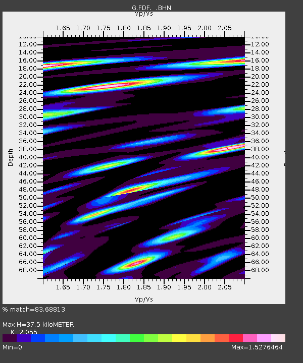
| Estimated Moho Depth: |
37.5 km |
| Estimated Crust Vp/Vs: |
2.06 |
| Assumed Crust Vp: |
5.88 km/s |
| Estimated Crust Vs: |
2.862 km/s |
| Estimated Crust Poisson's Ratio: |
0.34 |
|
| Radial Match: |
83.68813 % |
| Radial Bump: |
400 |
| Transverse Match: |
65.21846 % |
| Transverse Bump: |
400 |
| SOD ConfigId: |
4714 |
| Insert Time: |
2010-02-26 22:32:54.145 +0000 |
| GWidth: |
2.5 |
| Max Bumps: |
400 |
| Tol: |
0.001 |
|
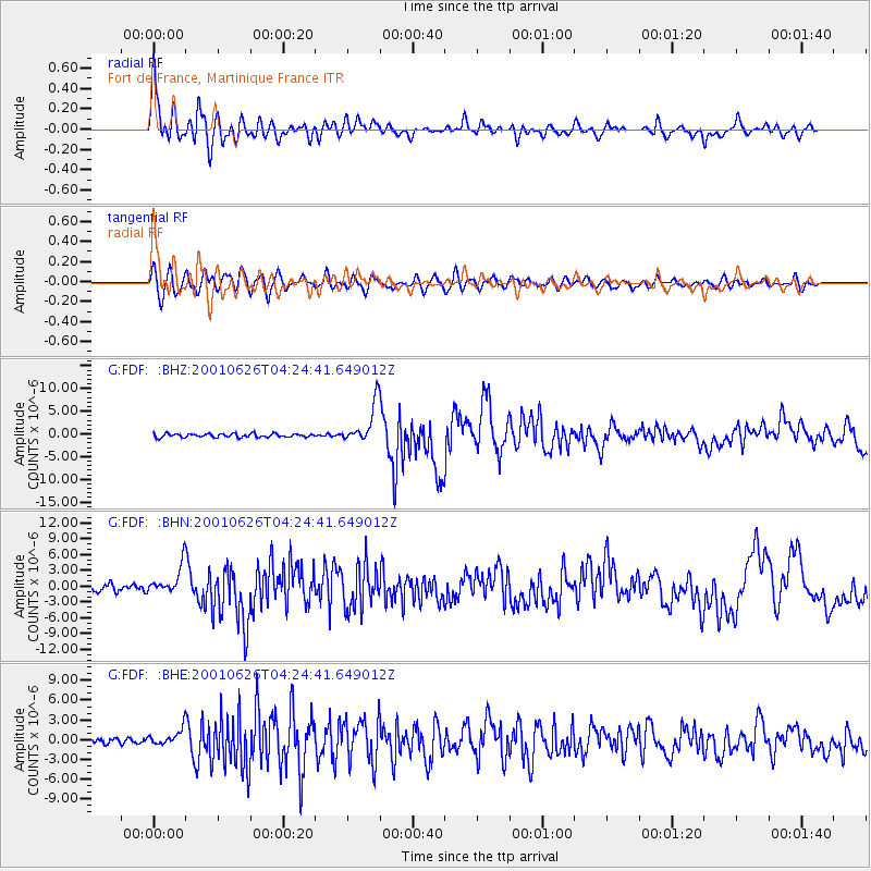
Signal To Noise
| Channel | StoN | STA | LTA |
| G:FDF: :BHN:20010626T04:24:41.649012Z | 4.153914 | 2.8166926E-6 | 6.7808156E-7 |
| G:FDF: :BHE:20010626T04:24:41.649012Z | 2.8826077 | 1.3154504E-6 | 4.5634042E-7 |
| G:FDF: :BHZ:20010626T04:24:41.649012Z | 11.490294 | 4.5068687E-6 | 3.9223266E-7 |
| Arrivals |
| Ps | 7.1 SECOND |
| PpPs | 18 SECOND |
| PsPs/PpSs | 26 SECOND |


