You are here: Home > Network List > TA - USArray Transportable Network (new EarthScope stations) Stations List
> Station O03D Paynes Creek, CA, USA > Earthquake Result Viewer
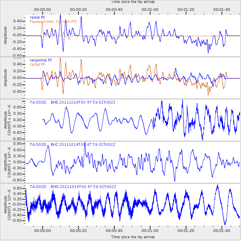
O03D Paynes Creek, CA, USA - Earthquake Result Viewer
*The percent match for this event was below the threshold and hence no stack was calculated.
| Earthquake location: |
Eastern New Guinea Reg., P.N.G. |
| Earthquake latitude/longitude: |
-6.6/147.9 |
| Earthquake time(UTC): |
2011/10/14 (287) 03:35:14 GMT |
| Earthquake Depth: |
37 km |
| Earthquake Magnitude: |
5.7 MB, 6.5 MS, 6.5 MW, 6.5 MW |
| Earthquake Catalog/Contributor: |
WHDF/NEIC |
|
| Network: |
TA USArray Transportable Network (new EarthScope stations) |
| Station: |
O03D Paynes Creek, CA, USA |
| Lat/Lon: |
40.29 N/121.80 W |
| Elevation: |
968 m |
|
| Distance: |
94.4 deg |
| Az: |
50.099 deg |
| Baz: |
265.202 deg |
| Ray Param: |
$rayparam |
*The percent match for this event was below the threshold and hence was not used in the summary stack. |
|
| Radial Match: |
66.31294 % |
| Radial Bump: |
400 |
| Transverse Match: |
57.69458 % |
| Transverse Bump: |
400 |
| SOD ConfigId: |
424168 |
| Insert Time: |
2012-02-08 02:34:59.193 +0000 |
| GWidth: |
2.5 |
| Max Bumps: |
400 |
| Tol: |
0.001 |
|
Signal To Noise
| Channel | StoN | STA | LTA |
| TA:O03D: :BHZ:20111014T03:47:59.625002Z | 3.5388312 | 4.3934824E-7 | 1.2415066E-7 |
| TA:O03D: :BHN:20111014T03:47:59.625002Z | 0.5260925 | 1.4282642E-7 | 2.7148533E-7 |
| TA:O03D: :BHE:20111014T03:47:59.625002Z | 1.2416098 | 3.461342E-7 | 2.7877854E-7 |
| Arrivals |
| Ps | |
| PpPs | |
| PsPs/PpSs | |


