You are here: Home > Network List > TA - USArray Transportable Network (new EarthScope stations) Stations List
> Station H17A Grant Village (NPS), Yellowstone Nt. Park, WY, USA > Earthquake Result Viewer
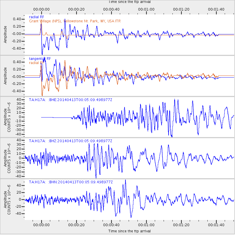
H17A Grant Village (NPS), Yellowstone Nt. Park, WY, USA - Earthquake Result Viewer
*The percent match for this event was below the threshold and hence no stack was calculated.
| Earthquake location: |
Solomon Islands |
| Earthquake latitude/longitude: |
-11.4/162.5 |
| Earthquake time(UTC): |
2014/04/12 (102) 23:52:15 GMT |
| Earthquake Depth: |
12 km |
| Earthquake Magnitude: |
5.0 mb |
| Earthquake Catalog/Contributor: |
ISC/ISC |
|
| Network: |
TA USArray Transportable Network (new EarthScope stations) |
| Station: |
H17A Grant Village (NPS), Yellowstone Nt. Park, WY, USA |
| Lat/Lon: |
44.40 N/110.58 W |
| Elevation: |
2400 m |
|
| Distance: |
95.7 deg |
| Az: |
45.998 deg |
| Baz: |
259.712 deg |
| Ray Param: |
$rayparam |
*The percent match for this event was below the threshold and hence was not used in the summary stack. |
|
| Radial Match: |
54.9601 % |
| Radial Bump: |
400 |
| Transverse Match: |
52.312206 % |
| Transverse Bump: |
400 |
| SOD ConfigId: |
3390531 |
| Insert Time: |
2019-04-11 08:35:39.648 +0000 |
| GWidth: |
2.5 |
| Max Bumps: |
400 |
| Tol: |
0.001 |
|
Signal To Noise
| Channel | StoN | STA | LTA |
| TA:H17A: :BHZ:20140413T00:05:09.498977Z | 5.04635 | 1.0323669E-5 | 2.0457696E-6 |
| TA:H17A: :BHN:20140413T00:05:09.498977Z | 4.635648 | 8.5354095E-6 | 1.841255E-6 |
| TA:H17A: :BHE:20140413T00:05:09.498977Z | 2.0747628 | 8.229084E-6 | 3.9662773E-6 |
| Arrivals |
| Ps | |
| PpPs | |
| PsPs/PpSs | |


