You are here: Home > Network List > TA - USArray Transportable Network (new EarthScope stations) Stations List
> Station S37A Fort Scott, KS, USA > Earthquake Result Viewer
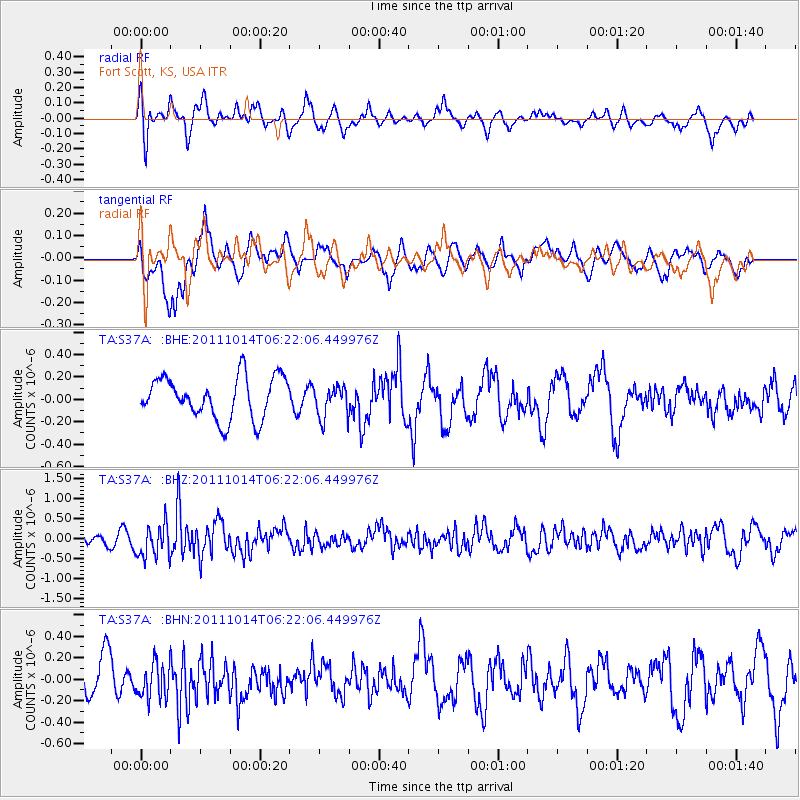
S37A Fort Scott, KS, USA - Earthquake Result Viewer
*The percent match for this event was below the threshold and hence no stack was calculated.
| Earthquake location: |
Southeastern Siberia, Russia |
| Earthquake latitude/longitude: |
54.1/123.7 |
| Earthquake time(UTC): |
2011/10/14 (287) 06:10:14 GMT |
| Earthquake Depth: |
12 km |
| Earthquake Magnitude: |
5.7 MB, 5.9 MS, 6.1 MW, 6.0 MW |
| Earthquake Catalog/Contributor: |
WHDF/NEIC |
|
| Network: |
TA USArray Transportable Network (new EarthScope stations) |
| Station: |
S37A Fort Scott, KS, USA |
| Lat/Lon: |
37.76 N/94.83 W |
| Elevation: |
260 m |
|
| Distance: |
82.7 deg |
| Az: |
29.867 deg |
| Baz: |
338.27 deg |
| Ray Param: |
$rayparam |
*The percent match for this event was below the threshold and hence was not used in the summary stack. |
|
| Radial Match: |
78.775314 % |
| Radial Bump: |
400 |
| Transverse Match: |
60.25333 % |
| Transverse Bump: |
400 |
| SOD ConfigId: |
424168 |
| Insert Time: |
2012-02-08 02:53:28.146 +0000 |
| GWidth: |
2.5 |
| Max Bumps: |
400 |
| Tol: |
0.001 |
|
Signal To Noise
| Channel | StoN | STA | LTA |
| TA:S37A: :BHZ:20111014T06:22:06.449976Z | 2.2468436 | 4.0863466E-7 | 1.8187055E-7 |
| TA:S37A: :BHN:20111014T06:22:06.449976Z | 1.3097985 | 1.6816877E-7 | 1.2839286E-7 |
| TA:S37A: :BHE:20111014T06:22:06.449976Z | 0.74606544 | 1.3873571E-7 | 1.859565E-7 |
| Arrivals |
| Ps | |
| PpPs | |
| PsPs/PpSs | |


