You are here: Home > Network List > G - GEOSCOPE Stations List
> Station FDF Fort de France, Martinique France > Earthquake Result Viewer
FDF Fort de France, Martinique France - Earthquake Result Viewer
| Earthquake location: |
Santiago Del Estero Prov., Arg. |
| Earthquake latitude/longitude: |
-26.7/-63.2 |
| Earthquake time(UTC): |
2008/09/03 (247) 11:25:14 GMT |
| Earthquake Depth: |
570 km |
| Earthquake Magnitude: |
5.9 MB, 6.3 MW, 6.3 MW |
| Earthquake Catalog/Contributor: |
WHDF/NEIC |
|
| Network: |
G GEOSCOPE |
| Station: |
FDF Fort de France, Martinique France |
| Lat/Lon: |
14.73 N/61.14 W |
| Elevation: |
467 m |
|
| Distance: |
41.3 deg |
| Az: |
3.055 deg |
| Baz: |
182.823 deg |
| Ray Param: |
0.070993 |
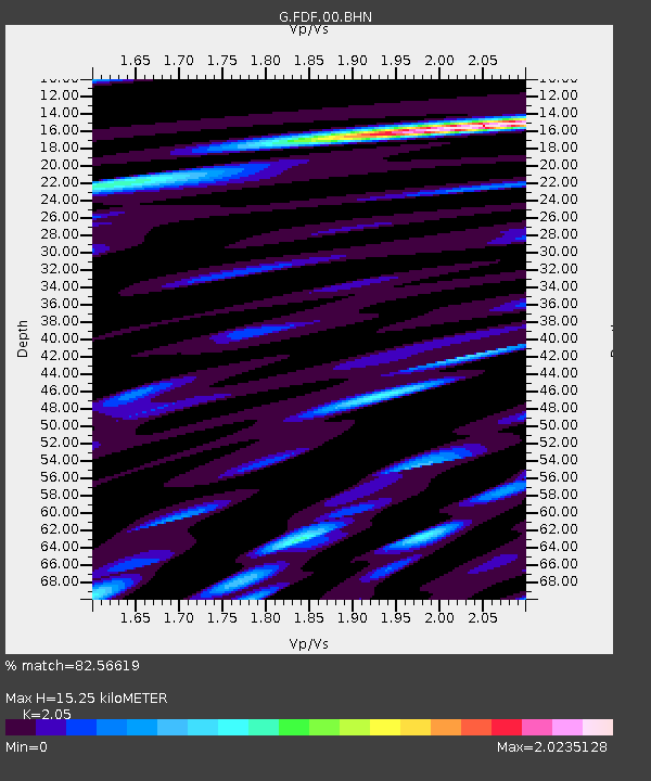
| Estimated Moho Depth: |
15.25 km |
| Estimated Crust Vp/Vs: |
2.05 |
| Assumed Crust Vp: |
5.88 km/s |
| Estimated Crust Vs: |
2.868 km/s |
| Estimated Crust Poisson's Ratio: |
0.34 |
|
| Radial Match: |
82.56619 % |
| Radial Bump: |
400 |
| Transverse Match: |
69.167046 % |
| Transverse Bump: |
400 |
| SOD ConfigId: |
2504 |
| Insert Time: |
2010-02-26 22:33:15.721 +0000 |
| GWidth: |
2.5 |
| Max Bumps: |
400 |
| Tol: |
0.001 |
|
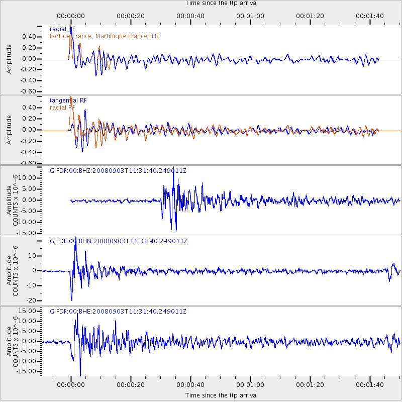
Signal To Noise
| Channel | StoN | STA | LTA |
| G:FDF:00:BHN:20080903T11:31:40.249011Z | 42.723686 | 8.664502E-6 | 2.0280325E-7 |
| G:FDF:00:BHE:20080903T11:31:40.249011Z | 16.182339 | 6.252113E-6 | 3.863541E-7 |
| G:FDF:00:BHZ:20080903T11:31:40.249011Z | 16.261538 | 5.0732115E-6 | 3.119761E-7 |
| Arrivals |
| Ps | 2.8 SECOND |
| PpPs | 7.6 SECOND |
| PsPs/PpSs | 10 SECOND |


