You are here: Home > Network List > CI - Caltech Regional Seismic Network Stations List
> Station TIN Tinemaha, Big Pine, CA, USA > Earthquake Result Viewer
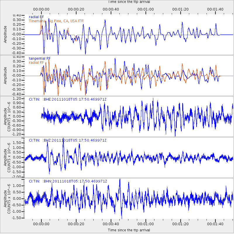
TIN Tinemaha, Big Pine, CA, USA - Earthquake Result Viewer
*The percent match for this event was below the threshold and hence no stack was calculated.
| Earthquake location: |
New Britain Region, P.N.G. |
| Earthquake latitude/longitude: |
-5.8/151.0 |
| Earthquake time(UTC): |
2011/10/18 (291) 05:05:06 GMT |
| Earthquake Depth: |
26 km |
| Earthquake Magnitude: |
5.5 MB, 5.9 MS, 6.0 MW, 6.1 MW |
| Earthquake Catalog/Contributor: |
WHDF/NEIC |
|
| Network: |
CI Caltech Regional Seismic Network |
| Station: |
TIN Tinemaha, Big Pine, CA, USA |
| Lat/Lon: |
37.05 N/118.23 W |
| Elevation: |
1197 m |
|
| Distance: |
94.0 deg |
| Az: |
53.314 deg |
| Baz: |
265.834 deg |
| Ray Param: |
$rayparam |
*The percent match for this event was below the threshold and hence was not used in the summary stack. |
|
| Radial Match: |
74.51013 % |
| Radial Bump: |
400 |
| Transverse Match: |
70.732544 % |
| Transverse Bump: |
400 |
| SOD ConfigId: |
424168 |
| Insert Time: |
2012-02-10 00:34:42.393 +0000 |
| GWidth: |
2.5 |
| Max Bumps: |
400 |
| Tol: |
0.001 |
|
Signal To Noise
| Channel | StoN | STA | LTA |
| CI:TIN: :BHZ:20111018T05:17:50.469971Z | 3.6344023 | 6.561021E-7 | 1.8052545E-7 |
| CI:TIN: :BHN:20111018T05:17:50.469971Z | 1.3363663 | 2.9609546E-7 | 2.2156759E-7 |
| CI:TIN: :BHE:20111018T05:17:50.469971Z | 1.6179432 | 2.7184453E-7 | 1.6801857E-7 |
| Arrivals |
| Ps | |
| PpPs | |
| PsPs/PpSs | |


