You are here: Home > Network List > CI - Caltech Regional Seismic Network Stations List
> Station BFS Mt Baldy Forest Station > Earthquake Result Viewer
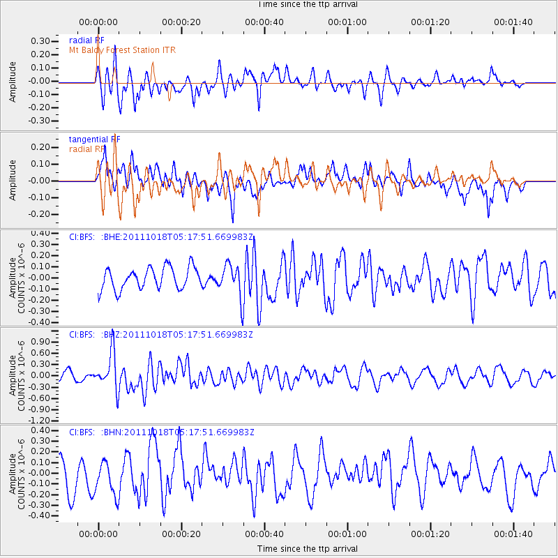
BFS Mt Baldy Forest Station - Earthquake Result Viewer
*The percent match for this event was below the threshold and hence no stack was calculated.
| Earthquake location: |
New Britain Region, P.N.G. |
| Earthquake latitude/longitude: |
-5.8/151.0 |
| Earthquake time(UTC): |
2011/10/18 (291) 05:05:06 GMT |
| Earthquake Depth: |
26 km |
| Earthquake Magnitude: |
5.5 MB, 5.9 MS, 6.0 MW, 6.1 MW |
| Earthquake Catalog/Contributor: |
WHDF/NEIC |
|
| Network: |
CI Caltech Regional Seismic Network |
| Station: |
BFS Mt Baldy Forest Station |
| Lat/Lon: |
34.24 N/117.66 W |
| Elevation: |
1312 m |
|
| Distance: |
94.3 deg |
| Az: |
56.157 deg |
| Baz: |
265.959 deg |
| Ray Param: |
$rayparam |
*The percent match for this event was below the threshold and hence was not used in the summary stack. |
|
| Radial Match: |
61.148056 % |
| Radial Bump: |
400 |
| Transverse Match: |
52.201027 % |
| Transverse Bump: |
400 |
| SOD ConfigId: |
424168 |
| Insert Time: |
2012-02-10 00:37:55.030 +0000 |
| GWidth: |
2.5 |
| Max Bumps: |
400 |
| Tol: |
0.001 |
|
Signal To Noise
| Channel | StoN | STA | LTA |
| CI:BFS: :BHZ:20111018T05:17:51.669983Z | 3.2511387 | 5.019292E-7 | 1.5438566E-7 |
| CI:BFS: :BHN:20111018T05:17:51.669983Z | 1.1390464 | 1.642701E-7 | 1.4421721E-7 |
| CI:BFS: :BHE:20111018T05:17:51.669983Z | 1.5726925 | 1.5284668E-7 | 9.71879E-8 |
| Arrivals |
| Ps | |
| PpPs | |
| PsPs/PpSs | |


