You are here: Home > Network List > G - GEOSCOPE Stations List
> Station FDF Fort de France, Martinique France > Earthquake Result Viewer
FDF Fort de France, Martinique France - Earthquake Result Viewer

| Earthquake location: |
Near Coast Of Peru |
| Earthquake latitude/longitude: |
-13.5/-76.7 |
| Earthquake time(UTC): |
2006/10/20 (293) 10:48:56 GMT |
| Earthquake Depth: |
23 km |
| Earthquake Magnitude: |
5.9 MB, 6.6 MS, 6.7 MW, 6.6 MW |
| Earthquake Catalog/Contributor: |
WHDF/NEIC |
|
| Network: |
G GEOSCOPE |
| Station: |
FDF Fort de France, Martinique France |
| Lat/Lon: |
14.73 N/61.14 W |
| Elevation: |
467 m |
|
| Distance: |
32.0 deg |
| Az: |
29.314 deg |
| Baz: |
209.493 deg |
| Ray Param: |
0.07883097 |
| Estimated Moho Depth: |
21.0 km |
| Estimated Crust Vp/Vs: |
1.87 |
| Assumed Crust Vp: |
5.88 km/s |
| Estimated Crust Vs: |
3.145 km/s |
| Estimated Crust Poisson's Ratio: |
0.30 |
|
| Radial Match: |
86.755516 % |
| Radial Bump: |
400 |
| Transverse Match: |
55.54287 % |
| Transverse Bump: |
400 |
| SOD ConfigId: |
2665 |
| Insert Time: |
2010-02-26 22:33:28.993 +0000 |
| GWidth: |
2.5 |
| Max Bumps: |
400 |
| Tol: |
0.001 |
|
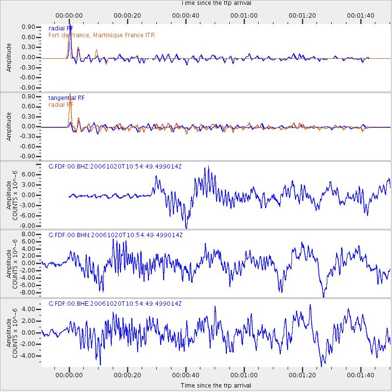
Signal To Noise
| Channel | StoN | STA | LTA |
| G:FDF:00:BHN:20061020T10:54:49.499014Z | 4.9136224 | 1.7935322E-6 | 3.6501223E-7 |
| G:FDF:00:BHE:20061020T10:54:49.499014Z | 4.2170997 | 1.1552496E-6 | 2.739441E-7 |
| G:FDF:00:BHZ:20061020T10:54:49.499014Z | 9.836803 | 3.0419274E-6 | 3.0923943E-7 |
| Arrivals |
| Ps | 3.3 SECOND |
| PpPs | 9.6 SECOND |
| PsPs/PpSs | 13 SECOND |


