You are here: Home > Network List > UW - Pacific Northwest Regional Seismic Network Stations List
> Station MRBL Marblemount, WA, USA > Earthquake Result Viewer
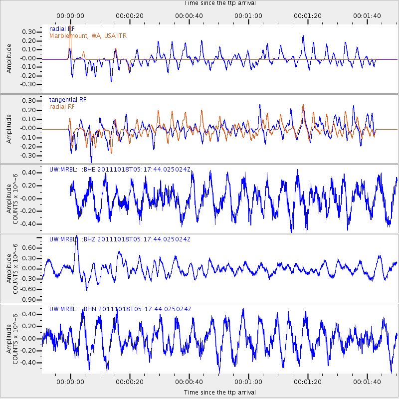
MRBL Marblemount, WA, USA - Earthquake Result Viewer
*The percent match for this event was below the threshold and hence no stack was calculated.
| Earthquake location: |
New Britain Region, P.N.G. |
| Earthquake latitude/longitude: |
-5.8/151.0 |
| Earthquake time(UTC): |
2011/10/18 (291) 05:05:06 GMT |
| Earthquake Depth: |
26 km |
| Earthquake Magnitude: |
5.5 MB, 5.9 MS, 6.0 MW, 6.1 MW |
| Earthquake Catalog/Contributor: |
WHDF/NEIC |
|
| Network: |
UW Pacific Northwest Regional Seismic Network |
| Station: |
MRBL Marblemount, WA, USA |
| Lat/Lon: |
48.52 N/121.48 W |
| Elevation: |
75 m |
|
| Distance: |
92.6 deg |
| Az: |
41.677 deg |
| Baz: |
264.297 deg |
| Ray Param: |
$rayparam |
*The percent match for this event was below the threshold and hence was not used in the summary stack. |
|
| Radial Match: |
53.531662 % |
| Radial Bump: |
359 |
| Transverse Match: |
62.487656 % |
| Transverse Bump: |
390 |
| SOD ConfigId: |
424168 |
| Insert Time: |
2012-02-10 00:46:01.036 +0000 |
| GWidth: |
2.5 |
| Max Bumps: |
400 |
| Tol: |
0.001 |
|
Signal To Noise
| Channel | StoN | STA | LTA |
| UW:MRBL: :BHZ:20111018T05:17:44.025024Z | 2.533793 | 3.904479E-7 | 1.5409621E-7 |
| UW:MRBL: :BHN:20111018T05:17:44.025024Z | 1.493147 | 2.2390908E-7 | 1.4995783E-7 |
| UW:MRBL: :BHE:20111018T05:17:44.025024Z | 0.6761678 | 1.1849205E-7 | 1.752406E-7 |
| Arrivals |
| Ps | |
| PpPs | |
| PsPs/PpSs | |


