You are here: Home > Network List > G - GEOSCOPE Stations List
> Station FDF Fort de France, Martinique France > Earthquake Result Viewer
FDF Fort de France, Martinique France - Earthquake Result Viewer
| Earthquake location: |
Gulf Of California |
| Earthquake latitude/longitude: |
28.2/-112.1 |
| Earthquake time(UTC): |
2006/01/04 (004) 08:32:32 GMT |
| Earthquake Depth: |
14 km |
| Earthquake Magnitude: |
6.1 MB, 6.7 MS, 6.6 MW, 6.5 MW |
| Earthquake Catalog/Contributor: |
WHDF/NEIC |
|
| Network: |
G GEOSCOPE |
| Station: |
FDF Fort de France, Martinique France |
| Lat/Lon: |
14.73 N/61.14 W |
| Elevation: |
467 m |
|
| Distance: |
49.0 deg |
| Az: |
94.783 deg |
| Baz: |
294.582 deg |
| Ray Param: |
0.06900191 |
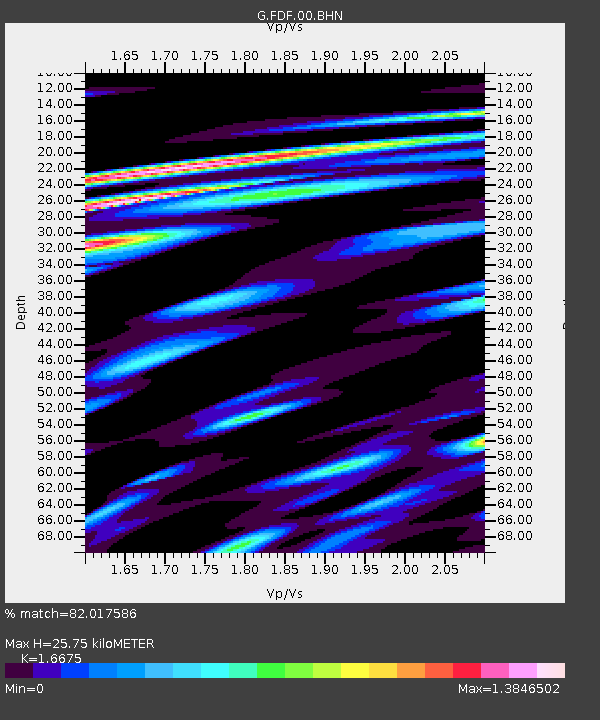
| Estimated Moho Depth: |
25.75 km |
| Estimated Crust Vp/Vs: |
1.67 |
| Assumed Crust Vp: |
5.88 km/s |
| Estimated Crust Vs: |
3.526 km/s |
| Estimated Crust Poisson's Ratio: |
0.22 |
|
| Radial Match: |
82.017586 % |
| Radial Bump: |
400 |
| Transverse Match: |
67.5161 % |
| Transverse Bump: |
400 |
| SOD ConfigId: |
4977 |
| Insert Time: |
2010-02-26 22:33:34.366 +0000 |
| GWidth: |
2.5 |
| Max Bumps: |
400 |
| Tol: |
0.001 |
|

Signal To Noise
| Channel | StoN | STA | LTA |
| G:FDF:00:BHN:20060104T08:40:47.250006Z | 1.2622842 | 1.0077625E-6 | 7.983642E-7 |
| G:FDF:00:BHE:20060104T08:40:47.250006Z | 1.6863902 | 1.0593142E-6 | 6.2815485E-7 |
| G:FDF:00:BHZ:20060104T08:40:47.250006Z | 3.2843666 | 1.6330555E-6 | 4.972208E-7 |
| Arrivals |
| Ps | 3.1 SECOND |
| PpPs | 11 SECOND |
| PsPs/PpSs | 14 SECOND |


