You are here: Home > Network List > II - Global Seismograph Network (GSN - IRIS/IDA) Stations List
> Station TAU Hobart, Tasmania, Australia > Earthquake Result Viewer
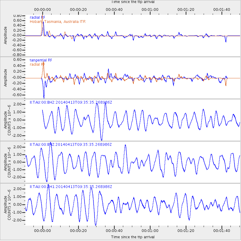
TAU Hobart, Tasmania, Australia - Earthquake Result Viewer
*The percent match for this event was below the threshold and hence no stack was calculated.
| Earthquake location: |
Solomon Islands |
| Earthquake latitude/longitude: |
-11.1/162.2 |
| Earthquake time(UTC): |
2014/04/13 (103) 09:29:21 GMT |
| Earthquake Depth: |
18 km |
| Earthquake Magnitude: |
5.5 MW |
| Earthquake Catalog/Contributor: |
ISC/ISC |
|
| Network: |
II Global Seismograph Network (GSN - IRIS/IDA) |
| Station: |
TAU Hobart, Tasmania, Australia |
| Lat/Lon: |
42.91 S/147.32 E |
| Elevation: |
132 m |
|
| Distance: |
34.2 deg |
| Az: |
199.55 deg |
| Baz: |
26.554 deg |
| Ray Param: |
$rayparam |
*The percent match for this event was below the threshold and hence was not used in the summary stack. |
|
| Radial Match: |
64.097916 % |
| Radial Bump: |
329 |
| Transverse Match: |
66.10716 % |
| Transverse Bump: |
400 |
| SOD ConfigId: |
3390531 |
| Insert Time: |
2019-04-11 08:47:25.614 +0000 |
| GWidth: |
2.5 |
| Max Bumps: |
400 |
| Tol: |
0.001 |
|
Signal To Noise
| Channel | StoN | STA | LTA |
| II:TAU:00:BHZ:20140413T09:35:35.268986Z | 1.8654509 | 1.7424774E-6 | 9.340784E-7 |
| II:TAU:00:BH1:20140413T09:35:35.268986Z | 2.6779535 | 1.4950605E-6 | 5.5828474E-7 |
| II:TAU:00:BH2:20140413T09:35:35.268986Z | 1.720749 | 1.6085655E-6 | 9.348054E-7 |
| Arrivals |
| Ps | |
| PpPs | |
| PsPs/PpSs | |


