You are here: Home > Network List > CI - Caltech Regional Seismic Network Stations List
> Station LGU LGU, Camarillo, CA, USA > Earthquake Result Viewer
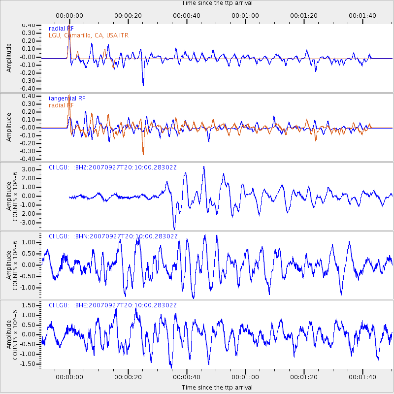
LGU LGU, Camarillo, CA, USA - Earthquake Result Viewer
| Earthquake location: |
Southeast Of Loyalty Islands |
| Earthquake latitude/longitude: |
-21.1/169.3 |
| Earthquake time(UTC): |
2007/09/27 (270) 19:57:44 GMT |
| Earthquake Depth: |
9.0 km |
| Earthquake Magnitude: |
6.2 MB, 6.3 MS, 6.1 MW, 6.1 MW |
| Earthquake Catalog/Contributor: |
WHDF/NEIC |
|
| Network: |
CI Caltech Regional Seismic Network |
| Station: |
LGU LGU, Camarillo, CA, USA |
| Lat/Lon: |
34.11 N/119.07 W |
| Elevation: |
416 m |
|
| Distance: |
87.5 deg |
| Az: |
52.027 deg |
| Baz: |
242.515 deg |
| Ray Param: |
0.04330281 |
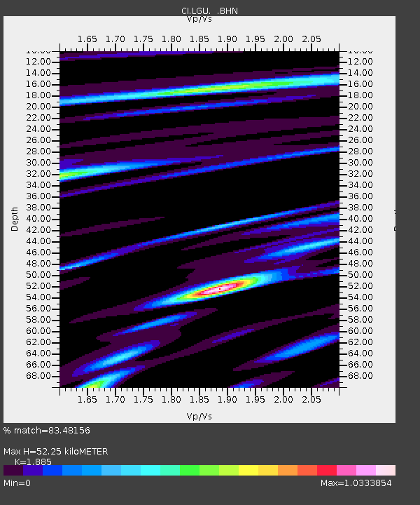
| Estimated Moho Depth: |
52.25 km |
| Estimated Crust Vp/Vs: |
1.88 |
| Assumed Crust Vp: |
6.1 km/s |
| Estimated Crust Vs: |
3.236 km/s |
| Estimated Crust Poisson's Ratio: |
0.30 |
|
| Radial Match: |
83.48156 % |
| Radial Bump: |
400 |
| Transverse Match: |
76.666725 % |
| Transverse Bump: |
400 |
| SOD ConfigId: |
2564 |
| Insert Time: |
2010-02-25 20:19:07.089 +0000 |
| GWidth: |
2.5 |
| Max Bumps: |
400 |
| Tol: |
0.001 |
|
Signal To Noise
| Channel | StoN | STA | LTA |
| CI:LGU: :BHN:20070927T20:10:00.28302Z | 0.7226444 | 1.9741249E-7 | 2.731807E-7 |
| CI:LGU: :BHE:20070927T20:10:00.28302Z | 0.9696193 | 2.3570804E-7 | 2.430934E-7 |
| CI:LGU: :BHZ:20070927T20:10:00.28302Z | 4.188092 | 7.358976E-7 | 1.757119E-7 |
| Arrivals |
| Ps | 7.7 SECOND |
| PpPs | 24 SECOND |
| PsPs/PpSs | 32 SECOND |


