You are here: Home > Network List > GE - GEOFON Stations List
> Station SUMG GEOFON Station Summit Camp, Greenland > Earthquake Result Viewer
SUMG GEOFON Station Summit Camp, Greenland - Earthquake Result Viewer
| Earthquake location: |
Hokkaido, Japan Region |
| Earthquake latitude/longitude: |
43.9/142.5 |
| Earthquake time(UTC): |
2011/10/21 (294) 08:02:37 GMT |
| Earthquake Depth: |
187 km |
| Earthquake Magnitude: |
5.9 MB, 6.1 MW, 6.1 MW |
| Earthquake Catalog/Contributor: |
WHDF/NEIC |
|
| Network: |
GE GEOFON |
| Station: |
SUMG GEOFON Station Summit Camp, Greenland |
| Lat/Lon: |
72.58 N/38.45 W |
| Elevation: |
3240 m |
|
| Distance: |
63.8 deg |
| Az: |
0.313 deg |
| Baz: |
359.249 deg |
| Ray Param: |
0.058760267 |
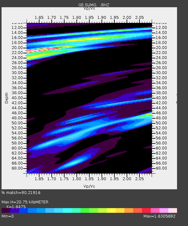
| Estimated Moho Depth: |
20.75 km |
| Estimated Crust Vp/Vs: |
1.65 |
| Assumed Crust Vp: |
6.261 km/s |
| Estimated Crust Vs: |
3.8 km/s |
| Estimated Crust Poisson's Ratio: |
0.21 |
|
| Radial Match: |
90.21916 % |
| Radial Bump: |
400 |
| Transverse Match: |
66.04042 % |
| Transverse Bump: |
400 |
| SOD ConfigId: |
424168 |
| Insert Time: |
2012-02-10 01:10:14.994 +0000 |
| GWidth: |
2.5 |
| Max Bumps: |
400 |
| Tol: |
0.001 |
|

Signal To Noise
| Channel | StoN | STA | LTA |
| GE:SUMG: :BHZ:20111021T08:12:19.494983Z | 26.89303 | 1.3460644E-5 | 5.005254E-7 |
| GE:SUMG: :BHN:20111021T08:12:19.494983Z | 4.8290024 | 4.3120112E-6 | 8.9294036E-7 |
| GE:SUMG: :BHE:20111021T08:12:19.494983Z | 2.2779264 | 1.2237849E-6 | 5.3723636E-7 |
| Arrivals |
| Ps | 2.2 SECOND |
| PpPs | 8.4 SECOND |
| PsPs/PpSs | 11 SECOND |


