You are here: Home > Network List > HW - Hanford Washington Seismic Network Stations List
> Station DDRF Dider Farm, Eltopia, WA, USA > Earthquake Result Viewer
DDRF Dider Farm, Eltopia, WA, USA - Earthquake Result Viewer
| Earthquake location: |
Hokkaido, Japan Region |
| Earthquake latitude/longitude: |
43.9/142.5 |
| Earthquake time(UTC): |
2011/10/21 (294) 08:02:37 GMT |
| Earthquake Depth: |
187 km |
| Earthquake Magnitude: |
5.9 MB, 6.1 MW, 6.1 MW |
| Earthquake Catalog/Contributor: |
WHDF/NEIC |
|
| Network: |
HW Hanford Washington Seismic Network |
| Station: |
DDRF Dider Farm, Eltopia, WA, USA |
| Lat/Lon: |
46.49 N/119.06 W |
| Elevation: |
233 m |
|
| Distance: |
64.8 deg |
| Az: |
49.054 deg |
| Baz: |
307.777 deg |
| Ray Param: |
0.05814301 |
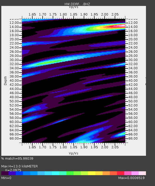
| Estimated Moho Depth: |
13.0 km |
| Estimated Crust Vp/Vs: |
2.10 |
| Assumed Crust Vp: |
6.419 km/s |
| Estimated Crust Vs: |
3.06 km/s |
| Estimated Crust Poisson's Ratio: |
0.35 |
|
| Radial Match: |
85.99039 % |
| Radial Bump: |
400 |
| Transverse Match: |
79.37911 % |
| Transverse Bump: |
400 |
| SOD ConfigId: |
424168 |
| Insert Time: |
2012-02-10 01:10:59.471 +0000 |
| GWidth: |
2.5 |
| Max Bumps: |
400 |
| Tol: |
0.001 |
|

Signal To Noise
| Channel | StoN | STA | LTA |
| HW:DDRF: :BHZ:20111021T08:12:25.674976Z | 6.8687344 | 6.4913706E-7 | 9.450606E-8 |
| HW:DDRF: :BHN:20111021T08:12:25.674976Z | 1.5713835 | 1.4820797E-7 | 9.431687E-8 |
| HW:DDRF: :BHE:20111021T08:12:25.674976Z | 2.4853787 | 2.230529E-7 | 8.974603E-8 |
| Arrivals |
| Ps | 2.3 SECOND |
| PpPs | 6.1 SECOND |
| PsPs/PpSs | 8.4 SECOND |


