You are here: Home > Network List > 2G - Testing of the effectiveness of incorporating seismic data in seismic hazard ass Stations List
> Station IUGFS Indiana Univ Geologic Field Station, Cardwell, MT > Earthquake Result Viewer
IUGFS Indiana Univ Geologic Field Station, Cardwell, MT - Earthquake Result Viewer
| Earthquake location: |
Solomon Islands |
| Earthquake latitude/longitude: |
-11.3/162.0 |
| Earthquake time(UTC): |
2014/04/13 (103) 10:05:37 GMT |
| Earthquake Depth: |
9.2 km |
| Earthquake Magnitude: |
5.6 MWC, 5.6 MWC |
| Earthquake Catalog/Contributor: |
NEIC PDE/NEIC COMCAT |
|
| Network: |
2G Testing of the effectiveness of incorporating seismic data in seismic hazard ass |
| Station: |
IUGFS Indiana Univ Geologic Field Station, Cardwell, MT |
| Lat/Lon: |
45.73 N/111.97 W |
| Elevation: |
1634 m |
|
| Distance: |
95.2 deg |
| Az: |
44.565 deg |
| Baz: |
259.333 deg |
| Ray Param: |
0.040837537 |
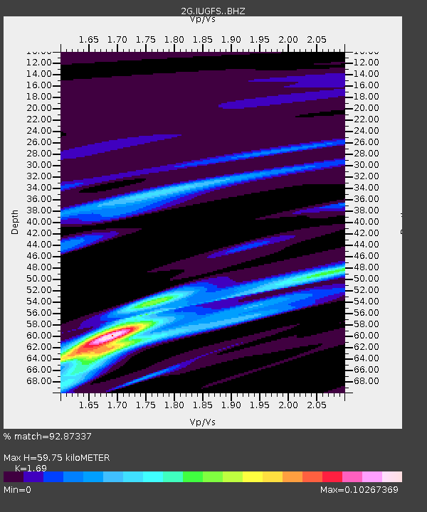
| Estimated Moho Depth: |
59.75 km |
| Estimated Crust Vp/Vs: |
1.69 |
| Assumed Crust Vp: |
6.35 km/s |
| Estimated Crust Vs: |
3.757 km/s |
| Estimated Crust Poisson's Ratio: |
0.23 |
|
| Radial Match: |
92.87337 % |
| Radial Bump: |
145 |
| Transverse Match: |
99.08397 % |
| Transverse Bump: |
64 |
| SOD ConfigId: |
3390531 |
| Insert Time: |
2019-04-11 08:49:40.760 +0000 |
| GWidth: |
2.5 |
| Max Bumps: |
400 |
| Tol: |
0.001 |
|

Signal To Noise
| Channel | StoN | STA | LTA |
| 2G:IUGFS: :BHZ:20140413T10:18:30.099993Z | 0.8219806 | 3.63988E-8 | 4.4281823E-8 |
| 2G:IUGFS: :BHN:20140413T10:18:30.099993Z | 0.8781937 | 4.577568E-8 | 5.212481E-8 |
| 2G:IUGFS: :BHE:20140413T10:18:30.099993Z | 1.185322 | 4.577721E-9 | 3.862006E-9 |
| Arrivals |
| Ps | 6.6 SECOND |
| PpPs | 25 SECOND |
| PsPs/PpSs | 31 SECOND |


