You are here: Home > Network List > IW - Intermountain West Stations List
> Station IMW Indian Meadow, Wyoming, USA > Earthquake Result Viewer
IMW Indian Meadow, Wyoming, USA - Earthquake Result Viewer
| Earthquake location: |
Hokkaido, Japan Region |
| Earthquake latitude/longitude: |
43.9/142.5 |
| Earthquake time(UTC): |
2011/10/21 (294) 08:02:37 GMT |
| Earthquake Depth: |
187 km |
| Earthquake Magnitude: |
5.9 MB, 6.1 MW, 6.1 MW |
| Earthquake Catalog/Contributor: |
WHDF/NEIC |
|
| Network: |
IW Intermountain West |
| Station: |
IMW Indian Meadow, Wyoming, USA |
| Lat/Lon: |
43.90 N/110.94 W |
| Elevation: |
2646 m |
|
| Distance: |
70.8 deg |
| Az: |
47.179 deg |
| Baz: |
312.816 deg |
| Ray Param: |
0.054209735 |
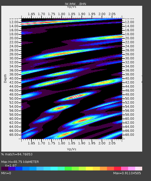
| Estimated Moho Depth: |
48.75 km |
| Estimated Crust Vp/Vs: |
1.87 |
| Assumed Crust Vp: |
6.207 km/s |
| Estimated Crust Vs: |
3.319 km/s |
| Estimated Crust Poisson's Ratio: |
0.30 |
|
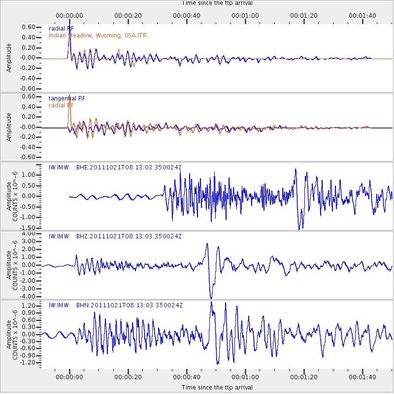
| Radial Match: |
94.76853 % |
| Radial Bump: |
400 |
| Transverse Match: |
89.60271 % |
| Transverse Bump: |
400 |
| SOD ConfigId: |
424168 |
| Insert Time: |
2012-02-10 01:12:40.443 +0000 |
| GWidth: |
2.5 |
| Max Bumps: |
400 |
| Tol: |
0.001 |
|
Signal To Noise
| Channel | StoN | STA | LTA |
| IW:IMW: :BHZ:20111021T08:13:03.350024Z | 7.9330735 | 5.174982E-7 | 6.5233E-8 |
| IW:IMW: :BHN:20111021T08:13:03.350024Z | 2.1936357 | 1.6040188E-7 | 7.312148E-8 |
| IW:IMW: :BHE:20111021T08:13:03.350024Z | 3.6775336 | 2.5350246E-7 | 6.8932735E-8 |
| Arrivals |
| Ps | 7.1 SECOND |
| PpPs | 22 SECOND |
| PsPs/PpSs | 29 SECOND |


