You are here: Home > Network List > CI - Caltech Regional Seismic Network Stations List
> Station LGU LGU, Camarillo, CA, USA > Earthquake Result Viewer
LGU LGU, Camarillo, CA, USA - Earthquake Result Viewer
| Earthquake location: |
Near West Coast Of Colombia |
| Earthquake latitude/longitude: |
3.0/-78.0 |
| Earthquake time(UTC): |
2007/09/10 (253) 01:49:14 GMT |
| Earthquake Depth: |
31 km |
| Earthquake Magnitude: |
6.1 MB, 6.7 MS, 6.8 MW |
| Earthquake Catalog/Contributor: |
WHDF/NEIC |
|
| Network: |
CI Caltech Regional Seismic Network |
| Station: |
LGU LGU, Camarillo, CA, USA |
| Lat/Lon: |
34.11 N/119.07 W |
| Elevation: |
416 m |
|
| Distance: |
49.2 deg |
| Az: |
313.913 deg |
| Baz: |
119.88 deg |
| Ray Param: |
0.068787605 |
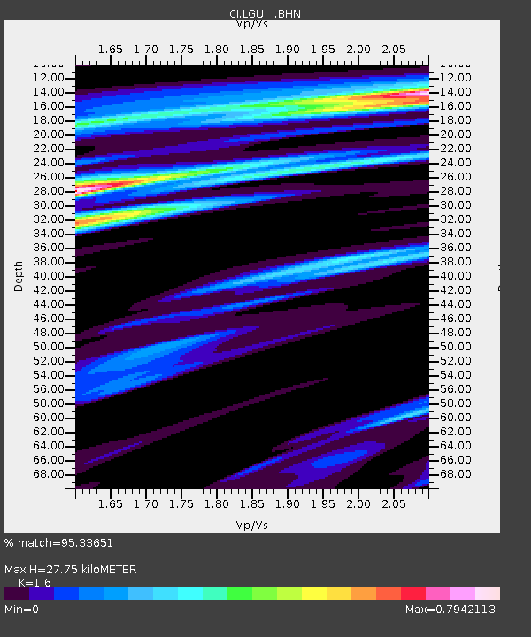
| Estimated Moho Depth: |
27.75 km |
| Estimated Crust Vp/Vs: |
1.60 |
| Assumed Crust Vp: |
6.1 km/s |
| Estimated Crust Vs: |
3.812 km/s |
| Estimated Crust Poisson's Ratio: |
0.18 |
|
| Radial Match: |
95.33651 % |
| Radial Bump: |
357 |
| Transverse Match: |
86.94885 % |
| Transverse Bump: |
400 |
| SOD ConfigId: |
2564 |
| Insert Time: |
2010-02-25 20:19:09.227 +0000 |
| GWidth: |
2.5 |
| Max Bumps: |
400 |
| Tol: |
0.001 |
|
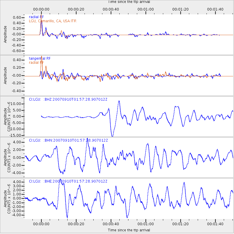
Signal To Noise
| Channel | StoN | STA | LTA |
| CI:LGU: :BHN:20070910T01:57:28.907012Z | 2.1347377 | 6.4170587E-7 | 3.0060173E-7 |
| CI:LGU: :BHE:20070910T01:57:28.907012Z | 2.6857464 | 6.688456E-7 | 2.4903528E-7 |
| CI:LGU: :BHZ:20070910T01:57:28.907012Z | 6.680868 | 1.9044438E-6 | 2.8505934E-7 |
| Arrivals |
| Ps | 2.9 SECOND |
| PpPs | 11 SECOND |
| PsPs/PpSs | 14 SECOND |


